Wyoming Highway 231
Wyoming Highway 231 (WYO 231) is a .6-mile-long (0.97 km) state highway in southeastern Lincoln County, Wyoming that serves as the main street of the town of Cokeville.
| ||||
|---|---|---|---|---|
| E. Main Street | ||||
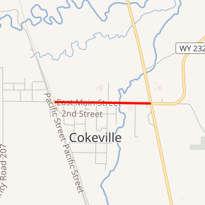
WYO 231 highlighted in red | ||||
| Route information | ||||
| Maintained by WYDOT | ||||
| Length | 0.6 mi[1] (1.0 km) | |||
| Major junctions | ||||
| West end | ||||
| East end | ||||
| Location | ||||
| Counties | Lincoln | |||
| Highway system | ||||
State highways in Wyoming
| ||||

Route description
Wyoming Highway 231 is a 1/2 mile long spur of US 30 locally known as E. Main Street. Highway 231's western terminus is at Collette Avenue (CR 207) which provides access to Cokeville Municipal Airport (via CR 207 south).[1][2] The east end of Highway 231 is at U.S. Route 30/Wyoming Highway 89 and the western terminus of WYO 232.[1][2]
Major intersections
The entire route is in Cokeville, Lincoln County.
| mi | km | Destinations | Notes | ||
|---|---|---|---|---|---|
| 0.0 | 0.0 | Western Terminus of WYO 231 | |||
| 0.6 | 0.97 | Eastern Terminus of WYO 231 | |||
| 1.000 mi = 1.609 km; 1.000 km = 0.621 mi | |||||
gollark: ```osmarks@fenrir /t/home> make dalegcc -o .ogcc: fatal error: no input filescompilation terminated.make: *** [<builtin>: .o] Error 1```now. I'll try with `make clean` then that.
gollark: Maybe I should just compile it manually.
gollark: Perhaps my copy of make is afflicted by a trusting trust attack launched by palaiologos which mysteriously breaks certain makefiles.
gollark: ```osmarks@fenrir /t/home> makegcc -Wall -g -c src/host/posix.c -o src/host/posixgcc -o .ogcc: fatal error: no input filescompilation terminated.make: *** [<builtin>: .o] Error 1```
gollark: `
References
- Official 2003 State Highway Map of Wyoming
- aaroads.com - Wyoming Routes 200-299
- Google (June 8, 2009). "overview map of WYO 231" (Map). Google Maps. Google. Retrieved June 8, 2009.
This article is issued from Wikipedia. The text is licensed under Creative Commons - Attribution - Sharealike. Additional terms may apply for the media files.