Wychwood Way
The Wychwood Way is a waymarked long-distance footpath in southern England in the United Kingdom.

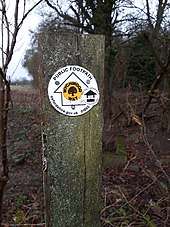
Wychwood Way footpath marker
Length of the Route
The route runs for 59.5 km (37 mi).
The route
The Wychwood Way runs through the ancient Royal Forest of Wychwood in West Oxfordshire.
It is a circular walk and starts from Woodstock, Oxfordshire passing through Stonesfield, Chadlington, Ascott-under-Wychwood, Leafield, Ramsden, North Leigh, East End, Oxfordshire, incorporates part of the Roman road of Akeman Street and the older route of the Saltway crossing Blenheim Park and links in with the Oxfordshire Way.
gollark: What? Heav uses my hosting cuboids™ successfully.
gollark: We have more than 4TB of storage you wouldn't be allowed to use if you signed up.
gollark: Our hosting cuboids™ are highly efficient, have more than 3% uptime, and are NOT magenta.
gollark: You could always use osmarkshosting™.
gollark: You could pregenerate art and add it, I suppose.
This article is issued from Wikipedia. The text is licensed under Creative Commons - Attribution - Sharealike. Additional terms may apply for the media files.