Worcester Street, Gloucester
Worcester Street in the City of Gloucester runs between the junction of Alvin Street and Kingsholm Road in the north and Northgate Street in the south.
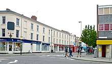
Worcester Street, south end, from Northgate Street.
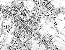
Worcester Street on Causton's 1843 map of Gloucester (top)
The street was developed in 1822 as an alternative route to Tewkesbury to replace the narrower Hare Lane and was promoted by John Phillpotts.[1] It is shown fully laid out on Causton's 1843 map.[2]
Buildings
Worcester Street is the location of a number of listed buildings:
gollark: PotatOS's registry allows convenient storage of all potatOS-related settings.
gollark: There's also the *debug* registry, which is different.
gollark: It uses a weird potatOS-specific binary format.
gollark: In the style of the Windows Registry.
gollark: No, the PotatOS Registry.
References
- Gloucester, 1720-1835: Topography. British History Online. Retrieved 18 April 2019.
- Causton’s 1843 map of Gloucester. Gloucester Maps and Prospects, Gloucestershire Archaeology. Retrieved 4 April 2019.
- Historic England. "18, 20, 22, Worcester Street (1272052)". National Heritage List for England. Retrieved 4 April 2019.
- Historic England. "38-60, Worcester Street (1272055)". National Heritage List for England. Retrieved 4 April 2019.
- Historic England. "83 and 85, Northgate Street, 1, Worcester Street (1245717)". National Heritage List for England. Retrieved 4 April 2019.
- Historic England. "5, Worcester Street (1245089)". National Heritage List for England. Retrieved 4 April 2019.
- Historic England. "9-17, Worcester Street (1272051)". National Heritage List for England. Retrieved 4 April 2019.
- Historic England. "19, 21, and 23, Worcester Street (1272053)". National Heritage List for England. Retrieved 4 April 2019.
- Historic England. "25, 27 and 29, Worcester Street (1272054)". National Heritage List for England. Retrieved 4 April 2019.
This article is issued from Wikipedia. The text is licensed under Creative Commons - Attribution - Sharealike. Additional terms may apply for the media files.