Wohlsdorf
Wohlsdorf is an Ortsteil (sub-district) of the town of Bernburg in Salzlandkreis, Saxony-Anhalt, Germany.
Wohlsdorf | |
|---|---|
Ortsteil of Bernburg | |
Location of Wohlsdorf within Salzlandkreis 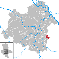 | |
 Wohlsdorf  Wohlsdorf | |
| Coordinates: 51°46′0″N 11°52′0″E | |
| Country | Germany |
| State | Saxony-Anhalt |
| District | Salzlandkreis |
| Town | Bernburg |
| Founded | 2010 |
| Area | |
| • Total | 7.48 km2 (2.89 sq mi) |
| Elevation | 71 m (233 ft) |
| Population (2016-12-31) | |
| • Total | 449 |
| • Density | 60/km2 (160/sq mi) |
| Time zone | CET/CEST (UTC+1/+2) |
| Postal codes | 06408 |
| Dialling codes | 034722 |
| Vehicle registration | SLK |
History
Wohlsdorf was first mentioned as a village 10 kilometres (6.2 mi) east of Bernburg in 986. It later became a municipality in the Salzlandkreis district and, in 2005, the community belonged to the historic collective municipality of Nienburg. When Nienburg was disbanded in 1 January 2010, it was incorporated into Bernburg, along with the communities of Baalberge, Biendorf, Gröna, Peißen, Poley, and Preußlitz.
Geography
Included in Wohlsdorf is the village of Crüchern, which was also formerly a separate district. Much of the surrounding area is gently rolling farmland, broken up only by about 114 square kilometres (44 sq mi) of woods dividing Crüchern from Wholsdorf. The river Ziethe forms a border between the Wholsdorf subdistrict and the village of Mölz, a sub-district of Kleinpaschleben. The Ziethe flows first southwest then southeast along the border of the woods that stretch alongside Crüchern, forming a border between farmland and village of Wohlsdorf. It bends again southeasterly and around the western edge of Biendorf, another village-sub-district of Bradenburg on the southern border of Wohlsdorf.
Transportation
1.32 kilometres (0.82 mi) north of the village of Crüchern, Landesstraße 149 (L149) meets and becomes the continuation of federal road Bundesstraße 185 (B185) as it meets Bundesstraße 6n (B6n). Both highways run east towards Köthen, but B185 runs through Kleinpaschleben, Trinum, Großpaschleben, and Köthen while B6n runs parallel to B185, avoiding cities and towns by cutting through farmland and curving south around the city of Köthen to merge into north-south B183.
West of L149, B185 continues for 14 kilometres (8.7 mi) towards Bernburg, passing the Latdorf/Dröbel landfill between Latdorf and Dröbel until it meets international European route E49 and becomes B6.
Much of the traffic in Wohlsdorf is by car, but outside the subdistrict to the south in Biendorf are train and bus stations.
Demography
| Year | Pop. | ±% |
|---|---|---|
| 1965 | 807 | — |
| 1971 | 749 | −7.2% |
| 1981 | 646 | −13.8% |
| 1989 | 598 | −7.4% |
| 1990 | 578 | −3.3% |
| 1991 | 571 | −1.2% |
| 1992 | 561 | −1.8% |
| 1993 | 562 | +0.2% |
| 1994 | 557 | −0.9% |
| 1995 | 571 | +2.5% |
| 1996 | 566 | −0.9% |
| 1997 | 576 | +1.8% |
| 1998 | 575 | −0.2% |
| 1999 | 569 | −1.0% |
| 2000 | 574 | +0.9% |
| 2001 | 573 | −0.2% |
| 2002 | 551 | −3.8% |
| 2003 | 535 | −2.9% |
| 2004 | 523 | −2.2% |
| 2005 | 519 | −0.8% |
| 2006 | 519 | +0.0% |
| 2007 | 516 | −0.6% |
| 2008 | 505 | −2.1% |
| 2009 | 477 | −5.5% |
| 2010 | 476 | −0.2% |
| 2011 | 469 | −1.5% |
| 2012 | 459 | −2.1% |
| 2013 | 445 | −3.1% |
| 2014 | 426 | −4.3% |
| 2015 | 439 | +3.1% |
| 2016 | 449 | +2.3% |
References