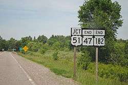
Wisconsin Highway 182
State Trunk Highway 182 (often called Highway 182, STH-182 or WIS 182) is a state highway in the U.S. state of Wisconsin. It runs east–west in northwest Wisconsin from Park Falls to Manitowish.
| ||||
|---|---|---|---|---|
| Route information | ||||
| Maintained by WisDOT | ||||
| Length | 33.41 mi[1] (53.77 km) | |||
| Existed | 1948[2]–present | |||
| Major junctions | ||||
| West end | ||||
| East end | ||||
| Location | ||||
| Counties | Price, Iron | |||
| Highway system | ||||
| ||||
Route description
Starting at the intersection with WIS 13 (South 4th Avenue) in downtown Park Falls, WIS 182 heads eastward through town and crosses the North Fork of the Flambeau River. West of the river, the highway follows 1st Street South and Birch Street east of the river. Outside of town, the environment takes on a woodland character as the highway passes through the Chequamegon National Forest in rural Price County. The roadway turns northward and crosses into Iron County. In this area, it passes several small lakes before meeting a junction with WIS 47. The two highways merge and run concurrently northward for about four miles (6.4 km). At the intersection with US Highway 51 (US 51), WIS 47 and WIS 182 jointly terminate south of Manitowish.[3]
History
WIS 182 was designated along a section of roadway that was previously County Trunk Highway G (CTH-G) in 1948. The routing has remained unchanged since.[2]
Major intersections

| County | Location | mi[1] | km | Destinations | Notes |
|---|---|---|---|---|---|
| Price | Park Falls | 0.00 | 0.00 | ||
| Iron | Town of Sherman | 29.65 | 47.72 | Southern end of WIS 47 overlap | |
| Manitowish | 33.41 | 53.77 | Northern end of WIS 47 overlap | ||
1.000 mi = 1.609 km; 1.000 km = 0.621 mi
| |||||
See also
![]()
References
| Wikimedia Commons has media related to Wisconsin Highway 182. |
- North Central Region (December 31, 2008). State Trunk Highway Log for Region 4. Rhinelander, WI: Wisconsin Department of Transportation.
- Bessert, Christopher J. (January 31, 2009). "Highways 180–189". Wisconsin Highways. Retrieved December 22, 2011.
- Google (December 22, 2011). "Overview Map of WIS 182" (Map). Google Maps. Google. Retrieved December 22, 2011.
