Wisconsin Highway 133
State Trunk Highway 133 (often called Highway 133, STH 133 or WIS 133) is a state highway in the U.S. state of Wisconsin. It runs in north–south in south central Wisconsin from near Tennyson to near Lone Rock.

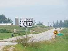
US 18/WIS 133 in Patch Grove
| ||||
|---|---|---|---|---|
| Route information | ||||
| Maintained by WisDOT | ||||
| Length | 91.07 mi[1] (146.56 km) | |||
| Major junctions | ||||
| South end | ||||
| North end | ||||
| Location | ||||
| Counties | Grant, Iowa, Richland | |||
| Highway system | ||||
| ||||
Major intersections
| County | Location | mi | km | Destinations | Notes |
|---|---|---|---|---|---|
| Grant | Tennyson | ||||
| Cassville | |||||
| Bloomington | Southern end of WIS 35 overlap | ||||
| Town of Patch Grove | Northern end of WIS 35 overlap; western end of US 18 overlap | ||||
| Mount Hope | Eastern end of US 18 overlap | ||||
| Boscobel | Western end of US 61 overlap | ||||
| Eastern end of US 61 overlap | |||||
| Muscoda | Western end of WIS 80 overlap | ||||
| Iowa | Town of Pulaski | Eastern end of WIS 80 overlap | |||
| Town of Clyde | Southern end of WIS 130 overlap | ||||
| Richland | Lone Rock | Northern end of WIS 130 overlap | |||
1.000 mi = 1.609 km; 1.000 km = 0.621 mi
| |||||
gollark: Although I don't think your justification is very reasonable - it's not remotely like coercing someone if you tell them to do something and it turns out that they have some sort of brain glitch which means they'll randomly unconditionally do it.
gollark: *You* haven't, I think, no.
gollark: Specific, LIMITED and well-defined ways.
gollark: Not restricted arbitrarily by social media platforms/political convenience.
gollark: Restricted somewhat in specific and well-defined ways, potentially.
References
- Bessert, Chris. "Wisconsin Highways: Highways 130-139 (Highway 133)". Wisconsin Highways. Retrieved 2007-03-20.
This article is issued from Wikipedia. The text is licensed under Creative Commons - Attribution - Sharealike. Additional terms may apply for the media files.
