Williamson Peninsula
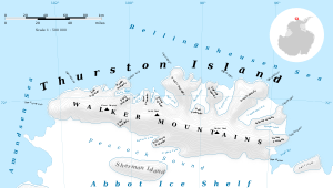
Williamson Peninsula (72°27′S 99°18′W) is an ice-covered peninsula midway along the south side of Thurston Island. It extends southwest into Abbot Ice Shelf between Schwartz Cove and O'Dowd Cove. Named by Advisory Committee on Antarctic Names (US-ACAN) after Lieutenant Commander H. E. Williamson, Medical Officer of the seaplane tender Pine Island in the Eastern Group of U.S. Navy Operation Highjump, 1946–47.

Map of Thurston Island.

Satellite image of Thurston Island.
Maps
- Thurston Island – Jones Mountains. 1:500000 Antarctica Sketch Map. US Geological Survey, 1967.
- Antarctic Digital Database (ADD). Scale 1:250000 topographic map of Antarctica. Scientific Committee on Antarctic Research (SCAR). Since 1993, regularly upgraded and updated.
![]()
![]()
gollark: Oops.
gollark: Overkill Reactor of Doom.
gollark: They changed the coolers or something.
gollark: It won't have the new changes, presumably.
gollark: I prefer NuclearCraft to the ReC reactors. The fission, anyway, its fusion reactor is boring.
This article is issued from Wikipedia. The text is licensed under Creative Commons - Attribution - Sharealike. Additional terms may apply for the media files.