White Hills (Arizona)
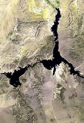
The White Hills are a range of hills in northern Mohave County, Arizona. These hills lie north of the Cerbat Mountains and extend south from the Colorado River at Lake Mead between the Detrital Valley to the west and the Gold Basin and the upper Hualapai Valley to the east.[2] The north region of the White Hills is located in Lake Mead National Recreation Area.
| White Hills (Arizona) | |
|---|---|
 | |
| Highest point | |
| Peak | Table Mountain (Arizona), south, near terminus |
| Elevation | 5,175 ft (1,577 m) |
| Coordinates | 35°53′16″N 114°21′06″W |
| Dimensions | |
| Length | 28 mi (45 km) N-S |
| Width | 11 mi (18 km) E-W (variable) |
| Geography | |
 White Hills (Arizona) White Hills in (northwest)-Arizona | |
| Country | United States |
| State | Arizona |
| Region | Mojave Desert |
| County | Mohave |
| Communities | White Hills, Arizona, Temple Bar, Arizona and Dolan Springs, Arizona |
| Borders on | |
The White Hills occur in a north, central, and south region. The approximate mountain range center is slightly northeast of White Hills, Arizona, the Senator Mountain, 5,127 feet (1,563 m).[3]
History
The west side of the White Hills were the site of a gold rush in 1892. It resulted in the establishment of the boomtown of White Hills, in Arizona Territory, twenty miles east of the steamboat landing at Eldorado Canyon.[4]:84
References
- Note: The white section is only the northwest of the range; directly east is half of a dark black terrain, northeast range section. (photo-width of lake ~36-mi; mtn. range width at north, ~16-mi.)
- U.S. Geological Survey Geographic Names Information System: White Hills
- Senator Mountain, topozone.com
- Richard E. Lingenfelter, Steamboats on the Colorado River, 1852-1916, University of Arizona Press, Tucson, 1978
External links

- Approx. mountain range center, Senator Mountain, northeast of White Hills, AZ, at topozone.com