Whangārei Heads
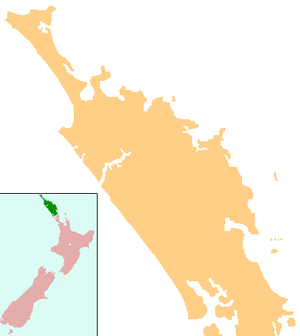
Whangārei Heads is a locality and promontory on the northern side of the Whangārei Harbour in Northland, New Zealand. Whangārei is 29 km (18 mi) to the north-west, and Ocean Beach is 8 km (5.0 mi) to the south-east, with Taurikura between the two. Mount Manaia rises to 420 metres (1,380 feet) to the east.[1][2]
Whangārei Heads | |
|---|---|
 Whangārei Heads School | |
 Whangārei Heads | |
| Coordinates: 35°49′2″S 174°30′14″E | |
| Country | New Zealand |
| Region | Northland Region |
| District | Whangārei District |
Immediately to the west is McLeod Bay, which is about 2 km (1.2 mi) long. The McDonald sandbank lies a few metres offshore at low tide. The promontory to the south of the settlement consists of a hill, Mount Aubrey, and a small gravel beach about 200 metres wide, Reotahi Bay.[3]
History
Gilbert Mair purchased the entire peninsula - everything south of a line running from McLeod Bay to the Pacific Coast, about 10,000 acres (0 km2) – from the Māori chief Te Tao, in 1839. He intended to resell it to Captain Bernard, but the latter was lost with his ship. The chief Te Tirarau claimed compensation of three horses because his ancestor had had blood spilt on the land, but settled for two horses in 1844. The government review of the land purchase in 1844 awarded Mair only 414 acres (1.7 km2), but Mair had sold his interest in the land to Logan Campbell.[4] Campbell pursued his claim to the remainder of the land.
A group of settlers from Nova Scotia, led by the Rev. Norman McLeod, settled at McLeod Bay in about 1855 although the ownership of the land had not been settled. In 1861, Campbell received the right to buy 1,800 acres (10 km2) at 10/- an acre, and was granted 910 acres (0 km2) which he sold to the Nova Scotians.[5]
Demographics
| Year | Pop. | ±% p.a. |
|---|---|---|
| 2006 | 1,062 | — |
| 2013 | 1,110 | +0.63% |
| 2018 | 1,392 | +4.63% |
| Source: [6] | ||
The statistical area of Bream Head, which at 52 square kilometres is much larger than this locality, had a population of 1,392 at the 2018 New Zealand census, an increase of 282 people (25.4%) since the 2013 census, and an increase of 330 people (31.1%) since the 2006 census. There were 570 households. There were 699 males and 696 females, giving a sex ratio of 1.0 males per female. Of the total population, 237 people (17.0%) were aged up to 15 years, 123 (8.8%) were 15 to 29, 687 (49.4%) were 30 to 64, and 348 (25.0%) were 65 or older. Figures may not add up to the total due to rounding.
Ethnicities were 94.2% European/Pākehā, 12.7% Māori, 2.2% Pacific peoples, 2.2% Asian, and 1.7% other ethnicities. People may identify with more than one ethnicity.
The percentage of people born overseas was 24.6, compared with 27.1% nationally.
Although some people objected to giving their religion, 63.4% had no religion, 27.2% were Christian, and 3.2% had other religions.
Of those at least 15 years old, 306 (26.5%) people had a bachelor or higher degree, and 147 (12.7%) people had no formal qualifications. The median income was $31,000. The employment status of those at least 15 was that 477 (41.3%) people were employed full-time, 183 (15.8%) were part-time, and 36 (3.1%) were unemployed.[6]
Education
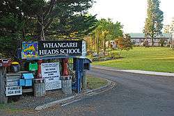
Whangarei Heads School is a coeducational full primary (years 1–8) school with a roll of 111 students as of March 2020.[7][8] The school was established in 1858, and is the second oldest school still in operation on its original site in the country.[9] The current principal is Jodi Edwards.[10]
References
- Peter Dowling (editor) (2004). Reed New Zealand Atlas. Reed Books. map 8. ISBN 0-7900-0952-8.CS1 maint: extra text: authors list (link)
- Smith, Roger (2005). The Geographic Atlas of New Zealand. Robbie Burton. map 28. ISBN 1-877333-20-4.
- Parkes, W. F. (1992). Guide to Whangarei City and District. Whangarei, N.Z.: Printed, published and distributed by Rossiter Printing. pp. 29–31. ISBN 0-473-01639-7.
- Pickmere, Nancy Preece (1986). Whangarei: The Founding Years. pp. 26–27.
- Pickmere, pp. 76–77.
- "Statistical area 1 dataset for 2018 Census". Statistics New Zealand. March 2020. Bream Head (108900). 2018 Census place summary: Bream Head
- "New Zealand Schools Directory". New Zealand Ministry of Education. Retrieved 26 April 2020.
- Education Counts: Whangarei Heads School
- "Whangarei Heads 150th Jubilee – Funding Application". Whangarei District Council. 20 November 2006.
- "Staff". Whangarei Heads School. Retrieved 17 May 2020.