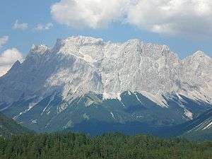
Wetterwandeck
The Wetterwandeck is a summit, 2,698 m high, in the Wetterstein mountains on the Austro-German border. It is located south of Germany's highest peak, the Zugspitze, above the Southern Schneeferner in the ridge which borders the Zugspitzplatt to the south.
| Wetterwandeck | |
|---|---|
 The Zugspitze massif with the Wetterwandeck in the centre | |
| Highest point | |
| Elevation | 2,698 m (8,852 ft) |
| Prominence | 30 |
| Parent peak | Southern Wetterspitze |
| Coordinates | 47°23′53″N 10°58′37″E |
| Geography | |
 Wetterwandeck Location in the Alps | |
| Location | Bavaria, Germany; Tyrol, Austria |
| Parent range | Wetterstein, Northern Limestone Alps |
| Climbing | |
| First ascent | 1874, Hermann von Barth |
The first verifiable ascent of the Wetterwandeck was in 1874 by Hermann von Barth.[1]
A drag lift in the ski region on the Zugspitzplatt below the Wetterwandeck was named after the mountain. There is also a piste at the southern foot of the mountain known as the Ehrwalder Almbahnen.
Climbing routes
- Wetterkante (800 metres in height, difficulty: UIAA V)
Sources
- Kompass Wander-, Bike und Skitourenkarte: Blatt 25 Zugspitze, Mieminger Kette (1:50.000). Kompass-Karten, Innsbruck 2008, ISBN 978-3-85491-026-8
gollark: The position is irrelevant.
gollark: Why?
gollark: 2a is -10, and you squared the b at the start for some reason?
gollark: This is also wrong.
gollark: See, this is why calculators.
References
- Hermann von Barth (1874). "Aus den Nördlichen Kalkalpen". Retrieved 14 May 2009.
This article is issued from Wikipedia. The text is licensed under Creative Commons - Attribution - Sharealike. Additional terms may apply for the media files.