West Virginia Route 84
West Virginia Route 84 is an east–west state highway located within Pocahontas County, West Virginia. The western terminus of the route is at West Virginia Route 92 in Frost. The eastern terminus is at the Virginia state line five miles (8 km) east of Frost, where WV 84 continues east as State Route 84.

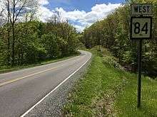
View west from the east end of WV 84 at SR 84 at the Virginia border near Frost
| ||||
|---|---|---|---|---|
| Route information | ||||
| Maintained by WVDOH | ||||
| Length | 4.6 mi[1] (7.4 km) | |||
| Major junctions | ||||
| West end | ||||
| East end | ||||
| Location | ||||
| Counties | Pocahontas | |||
| Highway system | ||||
| ||||
Major intersections
The entire route is in Pocahontas County.
| Location | mi | km | Destinations | Notes | |
|---|---|---|---|---|---|
| Frost | |||||
| | Virginia state line | ||||
| 1.000 mi = 1.609 km; 1.000 km = 0.621 mi | |||||
gollark: Are you concerned about the security of P2P potatoUPDATES™?
gollark: No, and why.
gollark: So this may eventually allow stuff like P2P potatoUPDATES™.
gollark: The first one is the actual data, the second one is metadata (currently just the hash of the data section).
gollark: You are wrong. Anyway, the manifests are effectively just two lines of deterministic JSON (i.e. JSON with all keys sorted and no whitespace, so it'll always hash the same way).
References
- Distance calculated using Microsoft MapPoint mapping software.
| Wikimedia Commons has media related to West Virginia Route 84. |
This article is issued from Wikipedia. The text is licensed under Creative Commons - Attribution - Sharealike. Additional terms may apply for the media files.
