West Virginia Route 73
West Virginia Route 73 is an east–west state highway located in the Logan, West Virginia area. The western terminus of the route is at an interchange with U.S. Route 119 a half-mile north of Verdunville and three miles (5 km) west of Logan. The eastern terminus is at West Virginia Route 10 outside Logan.
| ||||
|---|---|---|---|---|
| Route information | ||||
| Maintained by WVDOH | ||||
| Length | 2.4 mi[1] (3.9 km) | |||
| Major junctions | ||||
| West end | ||||
| East end | ||||
| Location | ||||
| Counties | Logan | |||
| Highway system | ||||
| ||||

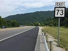
View east along WV 73 east of US 119 in Mount Gay-Shamrock
WV 73 intersects the northern terminus of West Virginia Route 44 a half-mile west of WV 10.
Major intersections
The entire route is in Logan County.
| Location | mi | km | Destinations | Notes | |
|---|---|---|---|---|---|
| | interchange | ||||
| Mount Gay | |||||
| | |||||
| 1.000 mi = 1.609 km; 1.000 km = 0.621 mi | |||||
gollark: You can refer to the wiki; it's helpful.
gollark: Yep.
gollark: Doesn't basically everyone do the refresh until drop thing?
gollark: <@284397085959258112> lineage?
gollark: 60 cheeses & 2 chickens? They're that rare?
References
- Distance calculated using Microsoft MapPoint mapping software.
| Wikimedia Commons has media related to West Virginia Route 73. |
This article is issued from Wikipedia. The text is licensed under Creative Commons - Attribution - Sharealike. Additional terms may apply for the media files.
