West Virginia Route 54
West Virginia Route 54 is a north–south state highway located in southern West Virginia. The southern terminus of the route is at West Virginia Route 16 in Mullens. The northern terminus is at WV 16 and West Virginia Route 97 in Sophia.
| ||||
|---|---|---|---|---|
| Route information | ||||
| Maintained by WVDOH | ||||
| Length | 18.6 mi[1] (29.9 km) | |||
| Major junctions | ||||
| South end | ||||
| North end | ||||
| Location | ||||
| Counties | Wyoming, Raleigh | |||
| Highway system | ||||
| ||||

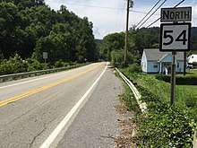
View north along WV 54 in Mullens
Major intersections
| County | Location | mi | km | Destinations | Notes |
|---|---|---|---|---|---|
| Wyoming | Mullens | ||||
| Maben | south end of WV 97 overlap | ||||
| Raleigh | Lester | ||||
| | interchange | ||||
| | north end of WV 97 overlap | ||||
1.000 mi = 1.609 km; 1.000 km = 0.621 mi
| |||||
gollark: My favourite in general is probably 3125 and the antimemetics division tale series based around that.
gollark: There's an entire series of several hundred.
gollark: The `where: {slug: "${slug}"}` bit?
gollark: This is entirely* serious.
gollark: I have lots of server administration experience from the test server I co-manage with about 450 bots and 25ish non-bot members.
References
- Distance calculated using Microsoft MapPoint mapping software.
| Wikimedia Commons has media related to West Virginia Route 54. |
This article is issued from Wikipedia. The text is licensed under Creative Commons - Attribution - Sharealike. Additional terms may apply for the media files.
