West Point (Seattle)
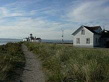
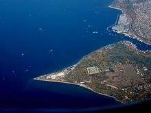
West Point is the westernmost point in Seattle, Washington, United States, jutting into Puget Sound from the Magnolia neighborhood. It also marks the northern extent of Elliott Bay; a line drawn southeastward to Alki Point marks the western extent of the bay. At the point itself is the 1881 West Point Lighthouse, the first manned light station on Puget Sound. Just to the east is King County's sewage treatment plant, and beyond that, Discovery Park, formerly the U.S. Army's Fort Lawton.
The original Duwamish Native American name for West Point, transliterated variously as PKa'dz Elue,[1] Oka-dz-elt-cu, Per-co-dus-chule, or Pka-dzEltcu, means "thrust far out." West Point was given its current name in 1841 by U.S. Navy lieutenant Charles Wilkes, commander of the United States Exploring Expedition.
In 1992, construction workers at the sewage treatment plant discovered archaeological remains of early Washington.
Notes
- Steve Wilke and Karen James, An Archeological Evaluation of the Fort Lawton Historical District, Seattle, Geo-Recon International (Seattle), July 1984. A report submitted to the City of Seattle Department of Parks and Recreation. p. 11.
External links
- U.S. Geological Survey Geographic Names Information System: West Point
- West Point Lighthouse
- "West Point Treatment Plant". Wastewater Treatment Division. King County, Washington.
- "West Point Treatment Plant". Wastewater Treatment Division. King County, Washington. Archived from the original on 1 May 2001.
- Archaeology of West Point
| Wikimedia Commons has media related to Fort Lawton West Point Lighthouse. |