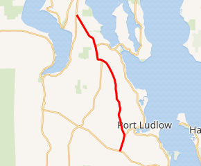
Washington State Route 19
State Route 19 (SR 19) is a 14.09-mile-long (22.68 km) state highway serving rural Jefferson County on the Olympic Peninsula in the U.S. state of Washington. The highway travels from SR 104 south of Port Ludlow and travels north through Chimacum and Port Hadlock-Irondale, intersecting SR 116, to end at SR 20 southwest of Port Townsend near the Jefferson County International Airport. SR 19 was established in 1991 on a roadway that had been built in the 1950s and paved in the 1960s.
| ||||
|---|---|---|---|---|

SR 19 highlighted in red | ||||
| Route information | ||||
| Defined by RCW 47.17.077 | ||||
| Maintained by WSDOT | ||||
| Length | 14.09 mi[1] (22.68 km) | |||
| Existed | 1991[2]–present | |||
| Major junctions | ||||
| South end | ||||
| North end | ||||
| Location | ||||
| Counties | Jefferson | |||
| Highway system | ||||
| ||||
Route description
SR 19 begins as Beaver Valley Road at an intersection with SR 104, a connector highway linking U.S. Route 101 to the Hood Canal Bridge, southwest the census-designated place of Port Ludlow.[3] The highway travels north as the western boundary of Port Ludlow and intersects Oak Bay Road, the primary access road for the community, before leaving Port Ludlow along Chimacum Creek to the west and Oak Bay to the east.[4][5] SR 19 crosses Chimacum Creek into the unincorporated community of Chimacum and becomes Rhody Drive and continues north into Port Hadlock-Irondale and intersecting Ness Corner Road, signed as SR 116, a connector to Indian Island and Fort Fagler State Park to the east.[6][7] The highway leaves Port Hadlock-Irondale as the Airport Cutoff Road and serves Jefferson County International Airport before ending at an intersection with SR 20 southwest of Port Townsend west of Fort Townsend State Park.[8][9][10]
Every year, the Washington State Department of Transportation (WSDOT) conducts a series of surveys on its highways in the state to measure traffic volume. This is expressed in terms of average annual daily traffic (AADT), which is a measure of traffic volume for any average day of the year. In 2011, WSDOT calculated that between 6,400 and 13,000 vehicles per day used the highway, mostly in near the Jefferson County International Airport.[11] SR 19 is designated as a part of the National Highway System from SR 104 to SR 116 and as a Highway of Statewide Significance for its whole route.[12][13][14]
History
SR 19 was designated in 1991 to serve the Jefferson County International Airport and connect to SR 116 in Port Hadlock-Irondale.[2] The highway was formally added to the state highway system on April 1, 1992.[15] The route of SR 19 roughly follows an existing unpaved road built by the 1950s and paved in the 1960s.[16][17][18]
Major intersections
The entire highway is in Jefferson County.
| Location | mi[1] | km | Destinations | Notes | |
|---|---|---|---|---|---|
| | 0.00 | 0.00 | Southern terminus | ||
| Port Hadlock-Irondale | 10.68 | 17.19 | Western terminus of SR 116 | ||
| | 14.09 | 22.68 | Northern terminus | ||
| 1.000 mi = 1.609 km; 1.000 km = 0.621 mi | |||||
References
- Staff (2012), State Highway Log: Planning Report 2011, SR 2 to SR 971 (PDF), Washington State Department of Transportation, pp. 516–518, retrieved January 29, 2013
- "47.17.077: State route No. 19", Revised Code of Washington, Washington State Legislature, 1991, retrieved January 29, 2013
- "Feature Detail Report for: Port Ludlow", Geographic Names Information System, United States Geological Survey, September 10, 1979, retrieved January 29, 2013
- "Feature Detail Report for: Oak Bay", Geographic Names Information System, United States Geological Survey, September 10, 1979, retrieved January 29, 2013
- "Feature Detail Report for: Chimacum Creek", Geographic Names Information System, United States Geological Survey, September 10, 1979, retrieved January 29, 2013
- "Feature Detail Report for: Chimacum", Geographic Names Information System, United States Geological Survey, September 10, 1979, retrieved January 29, 2013
- "Feature Detail Report for: Port Hadlock-Irondale Census Designated Place", Geographic Names Information System, United States Geological Survey, March 11, 2008, retrieved January 29, 2013
- "Feature Detail Report for: Jefferson County International Airport", Geographic Names Information System, United States Geological Survey, March 1, 1990, retrieved January 29, 2013
- "Feature Detail Report for: Old Fort Townsend State Park", Geographic Names Information System, United States Geological Survey, September 10, 1979, retrieved January 29, 2013
- Google (November 3, 2010). "State Route 19" (Map). Google Maps. Google. Retrieved November 3, 2010.
- Staff (2011), 2011 Annual Traffic Report (PDF), Washington State Department of Transportation, pp. 94–95, retrieved January 29, 2013
- National Highway System: Seattle, WA (PDF) (Map). Federal Highway Administration. October 1, 2012. Retrieved January 29, 2013.
- Transportation Commission List of Highways of Statewide Significance (PDF), Washington State Transportation Commission, July 26, 2009, archived from the original (PDF) on July 24, 2013, retrieved January 29, 2013
- Highways Of Statewide Significance (PDF) (Map). Washington State Department of Transportation. 2009. Retrieved January 29, 2013.
- Washington State Legislature (May 26, 1991), "Senate Bill 5801", Session Laws of the State of Washington, Session Laws of the State of Washington (1991 ed.), Olympia, Washington: Washington State Legislature,
A state highway to be known as state route number 19 is established as follows: Beginning at a junction with state route number 104, thence northerly to a junction with state route number 20 near Old Fort Townsend state park.
- Seattle, 1958 (JPG) (Map). 1:250,000. United States Geological Survey. 1958. Retrieved January 29, 2013.
- Seattle, 1965 (JPG) (Map). 1:250,000. United States Geological Survey. 1965. Retrieved January 29, 2013.
- Victoria, 1966 (JPG) (Map). 1:250,000. United States Geological Survey. 1966. Retrieved January 29, 2013.
