Warehouse District (Salt Lake City, Utah)
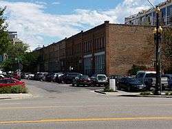
The Warehouse District of Salt Lake City, Utah, is a historic district on the city's west side. The area has been occupied by artists, and worked on by developers.[2] A small portion of its area was added to the National Register of Historic Places in 1982, and the listing was greatly enlarged by a boundary increase in 2016.
Warehouse District | |
 | |
  | |
| Location | 200 South and Pierpont Ave. between 300 and 400 West, and roughly bounded by I-15, US 50 S., W. Temple St., 300 West & 1000 South, Salt Lake City, Utah |
|---|---|
| Coordinates | 40°45′47″N 111°54′10″W |
| Area | 13 acres (5.3 ha) (original) 544 acres (220 ha) (increased) |
| Architect | Richard Kletting; Walter Ware; others |
| Architectural style | Early Commercial |
| MPS | Salt Lake City Business District MRA |
| NRHP reference No. | 82004149[1] (original) 16000125 (increase) |
| Significant dates | |
| Added to NRHP | August 17, 1982 March 22, 2016 (increase) |
| Boundary increase | March 22, 2016 |
Original district
"The original Warehouse District was listed on the National Register in 1982 and included 16 buildings with a somewhat undefined period of significance from approximately 1890 to 1927. The original district boundary encompasses a roughly 1-block area straddling 200 South between 300 West and 400 West in Salt Lake City. Of the 16 buildings in the original district, 15 were determined to be contributing resources..."[3]
The 15 contributing buildings, along odd then even sides of W. 2nd South, and then on other streets, were:[4]
- Keyser Warehouse (1920), 312 W. 2nd South
- Keyser Warehouse (1919), 320 W. 2nd South
- Keyser Warehouse (1909), 328 W. 2nd South
- Kahn Brothers grocery building (1900), 342 W. 2nd South
- Salt Lake Stamp Co. (1923), 380 W. 2nd South
- Crane Building (1910), 307 W. 2nd South
- Symns Wholesale Grocery Co. (1892–93), 327-331 W. 2nd South
- Jennings-Hanna Warehouse (1915), 353 W. 2nd South, brick and concrete, designed by Richard Kletting[4]:11
- Keyser Warehouse (c.1902), 357 S. 2nd South
- Henderson Block (1897–98), 379 W. 2nd South, designed by Walter Ware, separately listed on the National Register in 1978
- Cudahy Packing Co. (1918), 235 S. 400 West
- Keyser Warehouse (c.1902), 346 Pierpont Ave.
- Free Fanner's Market (1910), 333 Pierpont Ave.
- Nelson-Ricks Creamery (1927), 314 W. 3rd South
- Firestone Tire Co.(1925), 308 W. 3rd South
The one non-contributing intrusion was the Trucker's Cafe (c.1960), at 358 W. 2nd South.[4] It was later demolished. (cite the expansion document)
The district was listed as part of a group of about 35 listings in 1982, as a result of a study of the historic resources in the larger business district area.[4]
Expanded district
The district was expanded by a boundary increase listing in 2016, at which time additional documentation was published. The district is now nearly a square mile in area (it is 544 acres vs. 640 acres in a square mile). It has an irregular shape, roughly bounded by I-15, 50 South, West Temple Street, 300 West, and 1000 South.[3]
The expanded district listing was guided by the "Salt Lake City Business District MRA" document.[5]
The district includes 26 properties which were already separately listed on the National Register, and a total of 197 contributing resources. Many are warehouses and commercial sites, but the district also includes residential properties. To qualify as a contributing resource, a site in the district need to have been constructed in 1869-1966 and to have sustained only minimal physical alteration.[6]
Field studies in 2012 and 2015 identified four periods of development in the district:
- Railroads and Outside Influences 1869-1899 - 29 buildings, 20 contributing
- Commercialization and Immigration 1900-1928 - 102 buildings, 76 contributing
- Great Depression and World War II 1929-1945 - 31 buildings, 22 contributing
- Post-War Era 1946-1966 - 111 buildings, 78 contributing[6]
Architectural styles include Victorian, Classical Revival, Bungalow, Moderne, and other. Architects include Walter Ware, Alberto Treganza, Richard Kletting, Samuel Whitaker, and others.[6]
Old Pioneer Fort Site, also known as Pioneer Park, is included as a contributing resource in the district.
See also
- National Register of Historic Places listings in Salt Lake City, Utah
References
- "National Register Information System". National Register of Historic Places. National Park Service. July 9, 2010.
- Price, Tom. "Salt Lake City's arty west side - Sunset.com". Retrieved 7 September 2013.
- Sheri Murray Ellis; Sara Meess (January 21, 2016). "Warehouse District (Boundary Increase and Additional Documentation)" (PDF). Includes maps and 34 photos from 2015.
- John S. McCormick; Diana Johnson (September 1981). "National Register of Historic Places Inventory-Nomination: Salt Lake City Business District Multiple Resource Area". Retrieved May 22, 2019.
- Salt Lake City Business District MRA
- Amy Thompson (December 3, 2015). "Warehouse National Historic District Boundary Increase" (PDF). Salt Lake City Planning Division. Retrieved May 22, 2019.
External links
![]()