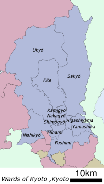
Wards of Kyoto
The city of Kyoto in Kyoto Prefecture, Japan has eleven wards.
| Name | Japanese | Established | Code[1] |
|---|---|---|---|
| Fushimi-ku | 伏見区 | 1931 (by merger of surrounding municipalities) | 261092 |
| Higashiyama-ku | 東山区 | 1921 (divided from Kamigyō) | 261050 |
| Kamigyō-ku | 上京区 | 1879 (one of original two wards) | 261025 |
| Kita-ku | 北区 | 1955 (divided from Kamigyō) | 261017 |
| Minami-ku | 南区 | 1955 (divided from Shimogyō) | 261076 |
| Nakagyō-ku | 中京区 | 1929 (divided from Kamigyō and Shimogyō) | 261041 |
| Nishikyō-ku | 西京区 | 1976 (divided from Ukyō) | 261114 |
| Sakyō-ku | 左京区 | 1929 (divided from Kamigyō) | 261033 |
| Shimogyō-ku | 下京区 | 1879 (one of original two wards) | 261068 |
| Ukyō-ku | 右京区 | 1931 (by merger of surrounding municipalities) | 261084 |
| Yamashina-ku | 山科区 | 1976 (divided from Higashiyama) | 261106 |
Wards of Kyoto
Unlike the 23 special wards of Tokyo, the wards of Kyoto are not separate municipalities, they are divisions just for municipal administration. Together, they comprise the city of Kyoto, under a single mayor and city council.
| Name | Population | Density (/km²) | Area (km²) | % of total | Forest Area (km²) | Forest Cover | Inhabitable Area | |
|---|---|---|---|---|---|---|---|---|
| (km²) | Density (/km²) | |||||||
| Fushimi-ku | 280,655 | 4,552 | 61.66 | 7.4% | 14.58 | 23.6% | 47.12 | 5,956 |
| Higashiyama-ku | 39,044 | 5,220 | 7.48 | 0.9% | 1.58 | 21.1% | 5.90 | 6,618 |
| Kamigyō-ku | 85,113 | 12,107 | 7.03 | 0.8% | 0.00 | 0.0% | 7.03 | 12,107 |
| Kita-ku | 119,474 | 1,259 | 94.88 | 11.5% | 78.85 | 83.1% | 16.02 | 7,458 |
| Minami-ku | 99,927 | 6,320 | 15.81 | 1.9% | 0.00 | 0.0% | 15.81 | 6,320 |
| Nakagyō-ku | 109,341 | 14,756 | 7.41 | 0.9% | 0.00 | 0.0% | 7.41 | 14,756 |
| Nishikyō-ku | 150,962 | 2,548 | 59.24 | 7.2% | 32.53 | 54.9% | 26.82 | 5,629 |
| Sakyō-ku | 168,266 | 682 | 246.77 | 29.8% | 215.26 | 87.2% | 31.55 | 5,333 |
| Shimogyō-ku | 82,668 | 12,193 | 6.78 | 0.8% | 0.00 | 0.0% | 6.78 | 12,193 |
| Ukyō-ku | 204,262 | 699 | 292.07 | 35.3% | 253.77 | 86.9% | 38.29 | 5,335 |
| Yamashina-ku | 135,471 | 4,720 | 28.70 | 3.5% | 13.64 | 47.5% | 15.40 | 8,797 |
| Total | 1,475,183 | 1,782 | 827.83 | 100.0% | 610.21 | 73.7% | 218.13 | 6,763 |
This article is issued from Wikipedia. The text is licensed under Creative Commons - Attribution - Sharealike. Additional terms may apply for the media files.