Wangford Rural District
Wangford Rural District was a rural district within the administrative county of East Suffolk between 1894 and 1934. It was created out of the earlier Wangford rural sanitary district.[1] It contained the group of small villages collectively known as The Saints.
| Wangford | |
|---|---|
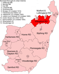 Location within East Suffolk, 1894 | |
| History | |
| • Created | 1894 |
| • Abolished | 1934 |
| • Succeeded by | Wainford Rural District |
| Status | Rural district |
In 1910 a new urban district of Bungay was created out of a part of the northern side of the district.[2]
In 1934, under a County Review Order, Wangford Rural District was abolished and its parishes transferred to the new Wainford Rural District. In 1974 the area became part of Waveney district.
Statistics
| Year | Area[3] | Population [4] |
Density (pop/ha) | |
|---|---|---|---|---|
| acres | ha | |||
| 1911 | 30,910 | 12,509 | 4,820 | 0.39 |
| 1921 | 4,605 | 0.37 | ||
| 1931 | 4,338 | 0.35 | ||
Parishes
Wangford RD contained the parishes of Bungay Holy Trinity and Bungay St Mary (until 1910); Barsham, Ellough, Flixton, Homersfield, Ilketshall (St Andrew, St John, St Lawrence & St Margaret), Mettingham, North Cove, Redisham, Ringsfield, Shadingfield, Shipmeadow, Sotterley, South Elmham (All Saints and St Nicholas, St Cross, St James, St Margaret, St Michael & St Peter), Weston, Willingham St Mary and Worlingham.
References
- "Wangford RD through time: Census tables with data for the Local Government District". A Vision of Britain through Time. GB Historical GIS / University of Portsmouth. Retrieved 10 July 2017.
- "Bungay CP through time: Census tables with data for the Local Government District". A Vision of Britain through Time. GB Historical GIS / University of Portsmouth. Retrieved 10 July 2017.
- "Wangford RD through time: Population Statistics: Area (acres)". A Vision of Britain through Time. GB Historical GIS / University of Portsmouth. Retrieved 10 July 2017.
- "Wangford RD through time: Population Statistics: Total Population". A Vision of Britain through Time. GB Historical GIS / University of Portsmouth. Retrieved 10 July 2017.