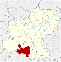
Wang Nam Khiao District
Wang Nam Khiao (Thai: วังน้ำเขียว, pronounced [wāŋ ná(ː)m kʰǐa̯w]) is a district (amphoe) in the southern part of Nakhon Ratchasima Province, northeastern Thailand.
Wang Nam Khiao วังน้ำเขียว | |
|---|---|
 District location in Nakhon Ratchasima Province | |
| Coordinates: 14°25′6″N 101°51′0″E | |
| Country | Thailand |
| Province | Nakhon Ratchasima |
| Seat | Wang Nam Khiao |
| Area | |
| • Total | 1,129.996 km2 (436.294 sq mi) |
| Population (2000) | |
| • Total | 41,485 |
| • Density | 36.7/km2 (95/sq mi) |
| Time zone | UTC+7 (ICT) |
| Postal code | 30370, 30150 |
| Geocode | 3025 |
History
The minor district (king amphoe) Wang Nam Khiao was created by separating the four tambons Wang Nam Khiao, Wang Mi, Udom Sap, and Raroeng of Pak Thong Chai district on 1 April 1992.[1] It was upgraded to a full district on 5 December 1996.[2]
Geography
Neighbouring districts are (from the north clockwise): Pak Thong Chai, Khon Buri of Nakhon Ratchasima Province; Na Di and Prachantakham of Prachinburi Province; Pak Chong and Sung Noen of Nakhon Ratchasima.
The Sankamphaeng Range mountainous area is in the southern part of this district.
Administration
The district is divided into five subdistricts (tambons). San Chao Pho is a township (thesaban tambon), which covers parts of the tambon Wang Nam Khiao and Thai Samakkhi.
| 1. | Wang Nam Khiao | วังน้ำเขียว | |
| 2. | Wang Mi | วังหมี | |
| 3. | Raroeng | ระเริง | |
| 4. | Udom Sap | อุดมทรัพย์ | |
| 5. | Thai Samakkhi | ไทยสามัคคี |
References
- ประกาศกระทรวงมหาดไทย เรื่อง แบ่งเขตท้องที่อำเภอปักธงชัย จังหวัดนครราชสีมา ตั้งเป็นกิ่งอำเภอวังน้ำเขียว (PDF). Royal Gazette (in Thai). 109 (53 ง special): 13. 22 April 1992.
- พระราชกฤษฎีกาตั้งอำเภอเหนือคลอง อำเภอนายายอาม อำเภอท่าตะเกียบ อำเภอขุนตาล อำเภอแม่ฟ้าหลวง อำเภอแม่ลาว อำเภอรัษฎา อำเภอพุทธมณฑล อำเภอวังน้ำเขียว อำเภอเจาะไอร้อง อำเภอชำนิ อำเภอโนนดินแดง อำเภอปางมะผ้า อำเภอสนธิ อำเภอหนองม่วง อำเภอเบญจลักษ์ อำเภอโพนนาแก้ว อำเภอบุ่งคล้า อำเภอดอนมดแดง และอำเภอลืออำนาจ พ.ศ. ๒๕๓๙ (PDF). Royal Gazette (in Thai). 113 (62 ก): 5–8. 20 November 1996.
External links
- http://www.wangnamkhiao.net Official Wangnamkhiao Tourist
- http://www.wnk.go.th Website of district (Thai)
- http://www.wangnamkeowdd.com Website of district (Thai)
- amphoe.com