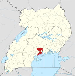
Wakiso Town
Wakiso is a city in the Central Region of Uganda. It is the headquarters of Wakiso District.[2]
Wakiso Wakiso Municipality | |
|---|---|
 Wakiso Location in Uganda | |
| Coordinates: 00°24′00″N 32°28′57″E | |
| Country | Uganda |
| Region | Central Region |
| District | Wakiso District |
| Elevation | 3,900 ft (1,200 m) |
| Population (2014 Census) | |
| • Total | 60,210[1] |
It is now growing at a fast rate due to the fact that it is neighboring Kampala.
Location
Wakiso is located on the Kampala-Hoima highway, approximately 20 kilometres (12 mi) north-west of Kampala, the capital and largest city of Uganda.[3] The coordinates of the town are 00 24 00N, 32 28 48E (Latitude:0.4000; Longitude:32.4800).[4]
Climate
Köppen-Geiger climate classification system classifies its climate as tropical rainforest (Af).[5]
| Climate data for Wakiso | |||||||||||||
|---|---|---|---|---|---|---|---|---|---|---|---|---|---|
| Month | Jan | Feb | Mar | Apr | May | Jun | Jul | Aug | Sep | Oct | Nov | Dec | Year |
| Average high °C (°F) | 28.8 (83.8) |
28.7 (83.7) |
28.2 (82.8) |
27.2 (81.0) |
26.7 (80.1) |
26.5 (79.7) |
26.1 (79.0) |
26.5 (79.7) |
27.3 (81.1) |
27.7 (81.9) |
27.8 (82.0) |
27.7 (81.9) |
27.4 (81.4) |
| Daily mean °C (°F) | 22.3 (72.1) |
22.5 (72.5) |
22.5 (72.5) |
22.2 (72.0) |
21.9 (71.4) |
21.3 (70.3) |
20.8 (69.4) |
21 (70) |
21.5 (70.7) |
22 (72) |
22.1 (71.8) |
22.8 (73.0) |
21.9 (71.5) |
| Average low °C (°F) | 15.9 (60.6) |
16.3 (61.3) |
16.9 (62.4) |
17.2 (63.0) |
17.1 (62.8) |
16.2 (61.2) |
15.5 (59.9) |
15.6 (60.1) |
15.8 (60.4) |
16.4 (61.5) |
16.4 (61.5) |
16 (61) |
16.3 (61.3) |
| Average precipitation mm (inches) | 70 (2.8) |
87 (3.4) |
133 (5.2) |
204 (8.0) |
147 (5.8) |
77 (3.0) |
69 (2.7) |
97 (3.8) |
109 (4.3) |
133 (5.2) |
150 (5.9) |
101 (4.0) |
1,377 (54.1) |
| Source: Climate-Data.org (altitude: 1112m)[5] | |||||||||||||
Population
The 2002 Uganda national census put the town's population at 20,073.[1] In 2010, the Uganda Bureau of Statistics (UBOS) estimated the population at 20,300.[6] In 2011, UBOS estimated the mid-year population at 21,200.[6] In August 2014, the national census put the population at 60,210.[1]
Points of interest
The following points of interest are found in Wakiso or close to the town's borders:
- Headquarters of Wakiso District
- Offices of Wakiso Town Council
- Wakiso central market
- Bunamwaya Stadium, a 5,000-seat stadium and home to the Vipers SC football club
See also
References
- Uganda Bureau of Statistics (29 October 2016). "The population of all Ugandan cities and towns with more than 15,000 inhabitants according to census results". Retrieved 3 June 2017 – via City Population.
- Joshua Kato, and Juliet Lukwago (24 October 2007). "Challenges of Turning Wakiso". New Vision. Kampala. Retrieved 23 April 2014.
- "Distance Between Kampala And Wakiso With Map". Gobefeed.com. Retrieved 23 April 2014.
- Google (2 July 2015). "Location of Wakiso At Google Maps" (Map). Google Maps. Google. Retrieved 2 July 2015.
- "Climate: Wakiso - Climate graph, Temperature graph, Climate table". Climate-Data.org. Retrieved 7 December 2013.
- UBOS. "Estimated Populations of Major Ugandan Urban Centers In 2002, 2010 & 2011" (PDF). Uganda Bureau of Statistics (UBOS). Retrieved 3 June 2017.
