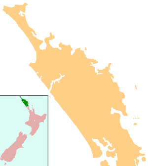
Waima, Northland
Waima (Māori: Waimā) is a community in the south Hokianga area of Northland, New Zealand. State Highway 12 runs through the area. The Waima River flows through the Waima Valley into the Hokianga Harbour. Rawene is to the north west, and Kaikohe is to the north east.[1][2]
Waima | |
|---|---|
 Waima | |
| Coordinates: 35°29′20″S 173°35′17″E | |
| Country | New Zealand |
| Region | Northland Region |
| District | Far North District |
Demographics
| Year | Pop. | ±% p.a. |
|---|---|---|
| 2006 | 1,029 | — |
| 2013 | 873 | −2.32% |
| 2018 | 1,095 | +4.64% |
| Source: [3] | ||
The statistical area of Waima Forest, which at 237 square kilometres is much larger than the community of Waima, had a population of 1,095 at the 2018 New Zealand census, an increase of 222 people (25.4%) since the 2013 census, and an increase of 66 people (6.4%) since the 2006 census. There were 318 households. There were 585 males and 510 females, giving a sex ratio of 1.15 males per female. Of the total population, 285 people (26.0%) were aged up to 15 years, 216 (19.7%) were 15 to 29, 465 (42.5%) were 30 to 64, and 129 (11.8%) were 65 or older. Figures may not add up to the total due to rounding.
Ethnicities were 32.1% European/Pākehā, 82.5% Māori, 8.8% Pacific peoples, 2.7% Asian, and 0.3% other ethnicities. People may identify with more than one ethnicity.
The percentage of people born overseas was 5.5, compared with 27.1% nationally.
Although some people objected to giving their religion, 38.9% had no religion, 38.1% were Christian, and 14.8% had other religions.
Of those at least 15 years old, 66 (8.1%) people had a bachelor or higher degree, and 210 (25.9%) people had no formal qualifications. The median income was $17,600. The employment status of those at least 15 was that 231 (28.5%) people were employed full-time, 108 (13.3%) were part-time, and 123 (15.2%) were unemployed.[3]
History and culture
Pre-European settlement
In 1810, an encounter at Waima during the Musket Wars resulted in the death of the Ngā Puhi chief Te Tauroto.[4][5] Te Whareumu was killed and Muriwai mortally wounded in a skirmish in March 1828.[6]
The chief of the sub tribe Te Mahurehure and Te Urikaiwhare was Mohi Tawhai (d.1875),[7] who was a signatory to the Treaty of Waitangi in 1840 and was known as the peace maker of the North.
European settlement
Waima was the site of a Wesleyan mission in the mid-19th century.[8] In the 1870s timber milling commenced in the area.[9]
In 1898, people of Waima refused to pay a tax on dogs, and marched on Rawene in the Dog Tax War.[10]
Notable people
- William Satchell, novelist and poet.[13]
Education
Waima School is a coeducational full primary (years 1-8) school[14] has a roll of 41 students as of March 2020.[15] The school was founded in 1881.[16] During the Dog Tax War of 1898, the government army of 120 men set up camp at Waima School.
Notes
- Peter Dowling (editor) (2004). Reed New Zealand Atlas. Reed Books. pp. map 7. ISBN 0-7900-0952-8.CS1 maint: extra text: authors list (link)
- Roger Smith, GeographX (2005). The Geographic Atlas of New Zealand. Robbie Burton. pp. map 22–23. ISBN 1-877333-20-4.
- "Statistical area 1 dataset for 2018 Census". Statistics New Zealand. March 2020. Waima Forest (102700). 2018 Census place summary: Waima Forest
- "POMARE II, Whetoi". Encyclopedia of New Zealand (1966).
- Smith, Stephenson Percy (1910). Maori Wars of the Nineteenth Century. p. 51.
- "Muriwai". Encyclopedia of New Zealand (1966).
- G. W. Rusden (1883). "XVIII. — 1874—1877. — Session of 1874". History of New Zealand. 3 (2nd ed.). Melville, Mullen and Slade. p. 84. Retrieved 30 November 2011.
- Michael King (2003). The Penguin History of New Zealand (7th ed.). p. 145. ISBN 0-14-301867-1.
- "Hokianga and Harbour". Encyclopedia of New Zealand (1966).
- "Northland - Government". Te Ara: The Encyclopedia of New Zealand.
- "Te Kāhui Māngai directory". tkm.govt.nz. Te Puni Kōkiri.
- "Māori Maps". maorimaps.com. Te Potiki National Trust.
- "SATCHELL, William". Encyclopedia of New Zealand (1966).
- Education Counts: Waima School
- "New Zealand Schools Directory". New Zealand Ministry of Education. Retrieved 26 April 2020.
- "Waima School 125th Jubilee". Education Gazette New Zealand. 19 June 2006.
External links

- Photographs of Waima held in Auckland Libraries' heritage collections.