Wagoner Inlet
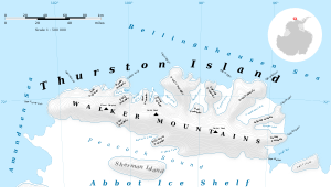
Wagoner Inlet (72°1′S 99°47′W) is an ice-filled inlet between Tinglof Peninsula and Starr Peninsula on the north side of Thurston Island. Delineated from aerial photos taken by U.S. Navy Operation Highjump in December 1946. Named by Advisory Committee on Antarctic Names (US-ACAN) for Charles Wagoner, seaman on the USS Glacier during the U.S. Navy Bellingshausen Sea Expedition, a member of the field party engaged in scientific work on Thurston Island in February 1960.

Wagoner Inlet
Location of Wagoner Inlet in Antarctica

Map of Thurston Island

Satellite image of Thurston Island
Maps
- Thurston Island – Jones Mountains. 1:500000 Antarctica Sketch Map. US Geological Survey, 1967.
- Antarctic Digital Database (ADD). Scale 1:250000 topographic map of Antarctica. Scientific Committee on Antarctic Research (SCAR), 1993–2016.
gollark: @AnarchoKarl#0976
gollark: @AnarchoKarl#0976
gollark: https://cdn.discordapp.com/attachments/461970193728667648/878681904277229578/video0.mov
gollark: Done.
gollark: I see. I'll inform our analysts.
References


This article is issued from Wikipedia. The text is licensed under Creative Commons - Attribution - Sharealike. Additional terms may apply for the media files.