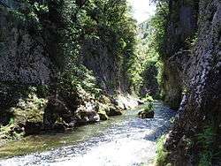
Vis (river)
The Vis is a 57.8-kilometre (35.9 mi) long river in south-central France, in the Occitanie administrative region. It is a right tributary of the Hérault. Its source is in the Cévennes, near the village of Alzon. It flows between the Causse du Larzac and the Causse de Blandas into the Hérault and Gard departments. The Vis flows into the Hérault near Ganges.
| Vis | |
|---|---|
 The Vis | |
.png) | |
| Native name | La Vis (French) |
| Location | |
| Country | France |
| Physical characteristics | |
| Source | |
| • location | Cévennes |
| Mouth | |
• location | Hérault |
• coordinates | 43°56′22″N 3°41′23″E |
| Length | 57.8 km (35.9 mi) |
| Basin size | 332 km2 (128 sq mi) |
| Discharge | |
| • average | 10 m3/s (350 cu ft/s) |
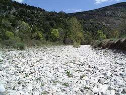
Vis sec
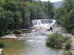
St Laurent le Minier
Origin of the name
The name "Vis" derives from the old Proto-Indo-European root "Vir" which means "river", and which can be found in the name of many rivers in France such as the Vire.
Towns along the river
The Vis flows through the following communes from source to mouth:
Hydrology and water quality
The Vis takes its source on the Saint-Guiral mount.[1]
gollark: I'm against change which isn't particularly useful-seeming and/or basically without notice.
gollark: The engineering/science split doesn't really bring significant advantages or disadvantages, except that the channel list is mildly longer.
gollark: indeed.
gollark: I mean... that's not really a very good way to think about these things?
gollark: "Advance" meaning "more than a few hours before".
See also
References
| Wikimedia Commons has media related to Vis River. |
- (in English) Cirque de Navacelles and the gorges of the Vis
- (in French) Banque Hydro - Station Y2035010 - La Vis à Saint-Laurent-le-Minier (Synthèse)
- (in French) Site du SANDRE
This article is issued from Wikipedia. The text is licensed under Creative Commons - Attribution - Sharealike. Additional terms may apply for the media files.