Villiers Island
Villiers Island is an island being built in Toronto's Portlands.[1][2][3][4] It is a 54 acres (22 hectares) parcel, bounded by what is now the Keating Channel, and a new channel.[5][6]
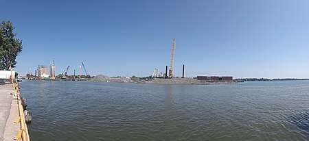
The island lies on former industrial land, first created through landfill, and the plan includes the preservation of some buildings considered to have heritage value.[7] These will either be moved to higher ground, or left in declivities, when additional landfill will be used to raise the ground level two metres in the event of rare extraordinary flooding.[8] Cherry Street will be realigned, and new bridges will be constructed.[9] More recent structures will be demolished.[10]
The island is located on a portion of the marsh once known as "Ashbridge's Bay", which had been the original natural mouth of the Don River. The entire Portlands had been a marsh, enclosed by the same large sandbar that formed the Toronto Islands.
By the turn of the 20th century, the marsh had become polluted, and the city filled it with landfill, and devoted it to industrial purposes.[11] Some of the early twentieth century landfill was also polluted, contaminated with heavy metals or toxic chemicals. The industrial enterprises were also polluting, including acres of petroleum tank farms and berms of road salt.
The city had also canalized and straightened the lower reach of the Don River, so it flowed straight for 5 kilometres (3.1 mi) from Bloor/Danforth to what is now Lake Shore Boulevard, where it made a right hand turn and ran 1 kilometre (0.62 mi) west in what was called the Keating Channel.[11]
Early in the 21st century suggestions were made that attempts should be made to "naturalize" the mouth of the Don River.[11] A second channel will be excavated. The second channel will have natural curves, and will have more natural banks, with natural plants that could provide habitat for migrating birds and wildlife. The second channel will empty into Toronto Harbour at what is now the Polson slip.
The Keating Channel had mooring for multiple freighters. Plans for Villiers Island included adding more natural looking curves on the Keating Channel's southern bank.
Plans show a greenbelt, and parkland, surrounding the developed center of the Island.[6]
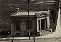 The Quantex Technology building, at the Corner of Cherry and Villiers, built in the 1920s as a bank, will be preserved when Villiers Island is developed.
 The Toronto Hydro-electric building, 281 Cherry Street, will be preserved when Villiers Island is developed.
.jpg) The Cherry Street Diner, NW corner of Cherry and Commissioner streets, will be preserved when Villiers Island is developed.
The Cherry Street Diner, NW corner of Cherry and Commissioner streets, will be preserved when Villiers Island is developed.
References
-
"INDEX TO AUTHORITY MEETING #8/14 Friday, October 31, 2014" (PDF). Toronto Region Conservation Authority. October 31, 2014. Archived (PDF) from the original on July 5, 2018.
On July 8th, thestar.com story, "Big Ideas: A new island to anchor the Port Lands" talks about Villiers Island, a project by TWRC, which aims to turn 54 acres of the Port Lands into a new lakefront area, complete with public art and streets lined with retail and mixed use residential properties. If the plan overcomes a long list of hurdles - including garnering at least $800 million in funding and an environmental assessment - the island will be created when TRCA rebuilds the mouth of the Don River. The move is part of a plan to protect Riverdale and the Port Lands from flooding.
-
Julian Mirabelli (August 9, 2018). "Eye-Catching Port Lands Bridges in the Works for Villiers Island". Urban Toronto. Archived from the original on October 23, 2018. Retrieved August 13, 2018.
The three bridges in question are the Cherry Street North Bridge (connecting Lake Shore Boulevard to Villiers Island); the Cherry Street South Bridge (connecting Villiers Island to the southern Port Lands); and the Commissioners Street Bridge (connecting Villiers Island to the eastern Port Lands). All three bridges are being designed by Entuitive, along with London-based Grimshaw Architects and SBP.
-
John Rieti (July 2, 2017). "Toronto's Port Lands plan includes building a new island". CBC News. Archived from the original on March 18, 2020. Retrieved August 13, 2018.
But Waterfront Toronto is confident Villiers Island — the first part of the development coming to the Port Lands — will be able to handle any flooding Lake Ontario and the Don River sends its way.
-
Tanya Mok (March 2018). "Toronto is getting a new Island". Blog TO. Archived from the original on March 18, 2020. Retrieved August 13, 2018.
By reconstructing the mouth of the Don River, the city will form a new river valley which will direct water into the Keating Channel and the flood harbour, thus creating Villiers Island in the Port Lands.
-
Tim Alamenciak (July 8, 2014). "Big Ideas: A new island to anchor the Port Lands". Toronto Star. Archived from the original on March 18, 2020. Retrieved July 5, 2018.
Villiers Island, a project by Waterfront Toronto, aims to turn 54 acres of the Port Lands into a new lakefront gem, complete with public art and streets lined with retail and mixed-use residential properties
-
"Villiers Island". Waterfront Toronto. 2017. Archived from the original on March 18, 2020. Retrieved July 5, 2018.
The Villiers Island precinct (formerly referred to as Cousins Quay) will be a stunning new waterfront community that embraces its distinct industrial functions and the spectacular new parks, public spaces and ecological richness that will result from the naturalization of the mouth of the Don River.
-
"Section three: Strategies and Guidelines" (PDF). City of Toronto government. 2017. Archived (PDF) from the original on March 18, 2020. Retrieved July 5, 2018.
Villiers Island is planned as Toronto’s first climate positive precinct. It will be developed as an innovative ‘climate positive’ community, demonstrating excellence in carbon reduction and sustainable neighbourhood design.
-
Kenyon Wallace (January 4, 2020). "How do you build an island in Toronto?". Toronto Star. Archived from the original on January 4, 2020. Retrieved March 18, 2020.
A new river valley alone doesn’t take Villiers Island out of the floodplain. The grade of the entire area will have to be raised an average of two metres to ensure storm water doesn’t breach the banks. This means parts of Commissioners Street, for example, will be raised by about six feet and rebuilt.
-
Morgan Bailey (February 28, 2020). "Catching Up With Work in Toronto's Port Lands". Urban Toronto. Archived from the original on March 18, 2020. Retrieved March 18, 2020.
Cherry Street will be realigned to the west of its current path and connected via a new bridge over the Keating Channel. A minor diversion will be created at the intersection of Cherry and Polson Streets starting in Spring 2020, ending in Winter 2021.
-
Tonya Mok (June 6, 2020). "The closest T&T Supermarket to Downtown Toronto is now almost completelydemolised". Blog TO. Retrieved June 7, 2020.
After 13 years on Cherry, T&T closed this January to make way for the a massive new district in the Port Lands.
- "Don Mouth Naturalization and Port Lands Flood Protection Project". Toronto and Region Conservation Authority. 2008. Archived from the original on December 11, 2007. Retrieved April 29, 2009.