Vertical exaggeration
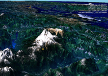
Vertical exaggeration (VE) is a scale that is used in raised-relief maps, plans and technical drawings (cross section perspectives), in order to emphasize vertical features, which might be too small to identify relative to the horizontal scale.[1]
Scaling Factor
The vertical exaggeration is given by:

where VS is the vertical scale and HS is the horizontal scale, both given as representative fractions.
For example, if 1 centimetre (0.39 in) vertically represents 200 metres (660 ft) and 1 centimetre (0.39 in) horizontally represents 4,000 metres (13,000 ft), the vertical exaggeration, 20×, is given by:
- .

Vertical exaggeration is given as a number; for example 5× means that vertical measurements are 5 times greater than horizontal measurements. The above example would be given as 20x. A value of 1× indicates that horizontal and vertical scales are identical, and is regarded as having "no vertical exaggeration." Vertical exaggerations less than 1 are not common, but would indicate a reduction in vertical scale (or, equivalently, a horizontal exaggeration).
In some cases, if the vertical exaggeration is too high, the map reader may get confused.
Criticism

Some scientists[2] [3] object to vertical exaggeration as a tool that makes an oblique visualization dramatic at the cost of misleading the viewer about the true appearance of the landscape.
References
- Introduction to Topographic Maps – Vertical Exaggeration
- David Morrison, "“Flat‐Venus Society” organizes", EOS, Volume 73, Issue 9, American Geophysical Union, 3 March 1992, p. 99. https://doi.org/10.1029/91EO00076. Retrieved 11 March 2019.
- Robert Simmon, "Elegant Figures What Not To Do: Vertical Exaggeration," NASA Earth Observatory, November 5, 2010. Retrieved 11 March 2019.