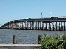
Verrazano Bridge (Maryland)
The Verrazano Bridge in Maryland is a bridge on Maryland Route 611[2] over Sinepuxent Bay that connects Assateague Island to the mainland.[3]
Verrazano Bridge | |
|---|---|
 The Verrazano Bridge | |
| Coordinates | 38.245734°N 75.149660°W |
| Carries | Two lanes of |
| Crosses | Sinepuxent Bay |
| Locale | Assateague Island, Maryland |
| Maintained by | Maryland State Highway Administration |
| ID number | 23018[1] |
| History | |
| Opened | 1964 |
| Statistics | |
| Daily traffic | 5,302[1] |
%26groups%3D_1349abfb9d580c21cedf5637cf936d6ad645462a.svg)
| |
The crossing, built in 1964,[4] contains two spans, one carrying automobiles and the other carrying pedestrians and bicycles.[5][3] It is owned by Maryland, not by the National Park Service.[6] NPS, however, does own part of Assateague Island.[7]
History
Like the larger and more famous Verrazzano-Narrows Bridge, it is named for Giovanni da Verrazzano. Unlike the Staten Island Ferry, which as of 2019 still continues as a free service, the Maryland "Ferry service ended when the Verrazano Bridge was built in 1964."[4]
Visitor Center
There is a Visitor Center on Route 611, right before the bridge.[8]
gollark: I have a hive of ethics in my back garden.
gollark: How?
gollark: Ethics is literal bees.
gollark: New moral system: it is virtuous to declare things virtues.
gollark: What makes virtues virtuous?
See also
References
- Maryland State Highway Administration (2009). "Highway Location Reference: Worcester County" (PDF). Retrieved August 22, 2010.
- "Assateague Island National Seashore (MD,VA)". 1982.
- Brenda Boitson (August 26, 2012). "Off-Beat And Unexpected—Assateague Island National Seashore".
The Verrazano bridge .. from mainland Maryland to the island
- "Assateague Island National Seashore" (PDF). NPShistory (US Department of the Interior). 2013.
- "Verrazano Bridge". National Historical Marker Database. Retrieved August 22, 2010.
- Kurt Repanshek (March 5, 2013). "Rebuilding After Sandy: How Assateague Island National Seashore Officials Are Dealing With Climate Change".
- "National Park Service" (PDF). 2017.
- Bryan MacKay (2018). Hike Maryland: A Guide to the Scenic Trails of the Free State. ISBN 1421424983.
This article is issued from Wikipedia. The text is licensed under Creative Commons - Attribution - Sharealike. Additional terms may apply for the media files.