Vermont Route 67
Vermont Route 67 (VT 67) is a 4.254-mile-long (6.846 km) east–west state highway in Bennington County, Vermont, United States. It runs from a continuation of New York State Route 67 at the New York state line in Shaftsbury to VT 7A farther east in the town. VT 67 also passes through the village of North Bennington.
| ||||
|---|---|---|---|---|
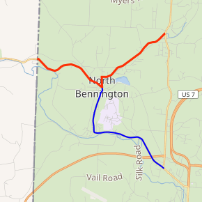
VT 67 highlighted in red, VT 67A in blue | ||||
| Route information | ||||
| Maintained by VTrans | ||||
| Length | 4.254 mi[1] (6.846 km) | |||
| Major junctions | ||||
| West end | ||||
| East end | ||||
| Location | ||||
| Counties | Bennington | |||
| Highway system | ||||
State highways in Vermont
| ||||

Route description
VT 67 starts at the New York state line as an eastward continuation of New York State Route 67. It curves twice, intersecting with White Creek Road, a continuation of Washington County, New York, County Route 68.
In North Bennington, VT 67 meets the northern terminus of VT 67A. As it does so, it curves straight north, with a secondary street (Houghton Street) leading to Lake Paran. After the intersection with Hawks Avenue, it takes a northeasterly path, ending at VT 7A in Shaftsbury.
History
VT 67 was assigned by 1935, when it was added to the Vermont state highway system as part of the 1935 state highway system expansion.[2]
Major intersections
The entire route is in Bennington County. [1]
| Location[1] | mi[1] | km | Destinations | Notes | |
|---|---|---|---|---|---|
| Shaftsbury | 0.000 | 0.000 | Continuation into New York | ||
| North Bennington | 2.021 | 3.252 | Northern terminus of VT 67A | ||
| Shaftsbury | 4.254 | 6.846 | Eastern terminus | ||
| 1.000 mi = 1.609 km; 1.000 km = 0.621 mi | |||||
Suffixed and special routes
Vermont Route 67A
| |
|---|---|
| Location | Bennington |
| Length | 3.348 mi[1] (5.388 km) |
Vermont Route 67A is a north–south state highway in Bennington County. It extends for 3.348 miles (5.388 km) from VT 7A in Bennington to VT 67 in North Bennington. VT 67A connects to VT 279 via an interchange located roughly 0.43 miles (0.69 km) north of VT 7A.[1]
- Major intersections
The entire route is in Bennington County.
| Location | mi[1] | km | Destinations | Notes | |
|---|---|---|---|---|---|
| Bennington | 0.000– 0.102 | 0.000– 0.164 | Access to VT 7A north and from VT 7A south via Berard Street | ||
| 0.324– 0.537 | 0.521– 0.864 | Interchange | |||
| North Bennington | 3.348 | 5.388 | |||
| Concurrency terminus • Closed • Unopened | |||||
Vermont Route 67A Connector
| |
|---|---|
| Location | Bennington |
| Existed | 1974–2004 |
Vermont Route 67A Connector was a connector route of VT 67A in Bennington. It was a short limited-access highway linking VT 67A to U.S. Route 7. VT 67A Connector was assigned in 1974[3] and removed in 2004 concurrent to the assignment of VT 279.[4]
References
- Traffic Research Unit (May 2013). "2012 (Route Log) AADTs for State Highways" (PDF). Policy, Planning and Intermodal Development Division, Vermont Agency of Transportation. Archived from the original (PDF) on March 4, 2016. Retrieved March 29, 2020.
- "State Highways History – 1931 and 1935 additions" (PDF). Vermont Agency of Transportation. October 5, 2007. Retrieved May 28, 2009.
- "State Highways History – Route Listing, Exclusive of Interstates with Route Log Notes" (PDF). Vermont Agency of Transportation, Policy and Planning Division – Mapping. October 5, 2007. Retrieved May 16, 2009.
- Office of the Governor (2004-10-08). "Western Leg of Bypass Will Open Tuesday". Archived from the original on 2006-09-23. Retrieved 2007-12-23.