Vermont Route 244
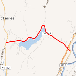
Vermont Route 244 (VT 244) is a state highway located within Orange County, Vermont, United States. The route runs from VT 113 in Thetford to U.S. Route 5 (US 5) in Fairlee. The highway is 5.640 miles (9.077 km) long and provides access to the Post Mills Airport from Interstate 91 (I-91) and US 5. VT 244 passes through the towns of Thetford, West Fairlee, and Fairlee, as well as the village of Post Mills.
| ||||
|---|---|---|---|---|

VT 244 highlighted in red | ||||
| Route information | ||||
| Maintained by VTrans | ||||
| Length | 5.640 mi[1] (9.077 km) | |||
| Major junctions | ||||
| West end | ||||
| East end | ||||
| Location | ||||
| Counties | Orange | |||
| Highway system | ||||
State highways in Vermont
| ||||
Route description
Vermont Route 244 begins at an intersection with Vermont Route 113 in the village of Post Mills, within the town of Thetford.[2] The highway traverses the shoreline of Lake Fairlee, traveling north through West Fairlee and Fairlee before turning southeast, crossing under Interstate 91 and terminating at an intersection with U.S. Route 5.[3][4]
Major intersections
The entire route is in Orange County. [1]
| Location[1] | mi[1] | km | Destinations | Notes | |
|---|---|---|---|---|---|
| Thetford | 0.000 | 0.000 | Western terminus | ||
| Fairlee | 5.640 | 9.077 | Eastern terminus | ||
| 1.000 mi = 1.609 km; 1.000 km = 0.621 mi | |||||
References
- Traffic Research Unit (May 2013). "2012 (Route Log) AADTs for State Highways" (PDF). Policy, Planning and Intermodal Development Division, Vermont Agency of Transportation. Retrieved April 25, 2015.
- "Vermont General Highway Map, Town of Thetford" (PDF). Vermont Agency of Transportation. 2003. Retrieved July 10, 2012.
- "Vermont General Highway Map, Town of West Fairlee" (PDF). Vermont Agency of Transportation. 2011. Retrieved July 10, 2012.
- "Vermont General Highway Map, Town of Fairlee" (PDF). Vermont Agency of Transportation. 2010. Retrieved July 10, 2012.
