Vaugondy Island
Vaugondy Island (Bulgarian: остров Вогонди, romanized: ostrov Vogondi, IPA: [ˈɔstrov voɡonˈdi]) is a mostly ice-covered island on the northeast side of Johannessen Harbour in the Pitt group of Biscoe Islands, Antarctica. The feature extends 1.85 km in north-south direction and 1.68 km in east-west.
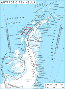 Location of Biscoe Islands in the Antarctic Peninsula region | |
 Vaugondy Island Location in Antarctica | |
| Geography | |
|---|---|
| Location | Antarctica |
| Coordinates | 65°24′37″S 65°21′47″W |
| Archipelago | Biscoe Islands |
| Administration | |
| Administered under the Antarctic Treaty System | |
| Demographics | |
| Population | Uninhabited |
The island is named after the French cartographer Didier Robert de Vaugondy (1723-1786) who published a map of the south polar region in 1777.
Location
Vaugondy Island is located 2.78 km west-southwest of Trundle Island, 1.1 km northwest of Jingle Island, 2.08 km east of Animas Island and 3.4 km south of Ribnik Island. British mapping in 1971.
Maps
- British Antarctic Territory: Graham Coast. Scale 1:200000 topographic map. DOS 610 Series, Sheet W 65 64. Directorate of Overseas Surveys, UK, 1971.
- Antarctic Digital Database (ADD). Scale 1:250000 topographic map of Antarctica. Scientific Committee on Antarctic Research (SCAR). Since 1993, regularly upgraded and updated.
References
- Bulgarian Antarctic Gazetteer. Antarctic Place-names Commission. (details in Bulgarian, basic data in English)
- Vaugondy Island. SCAR Composite Antarctic Gazetteer.
External links
- Vaugondy Island. Copernix satellite image
This article includes information from the Antarctic Place-names Commission of Bulgaria which is used with permission.