Vance Brand Airport
Vance Brand Airport (ICAO: KLMO, FAA LID: LMO, formerly AMR) is a city-owned public-use airport located three nautical miles (6 km) southwest of the central business district of Longmont, in Boulder County, Colorado, United States.[1] The Airport is named after former NASA astronaut Vance Brand.
Vance Brand Airport | |||||||||||
|---|---|---|---|---|---|---|---|---|---|---|---|
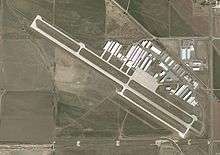
 USGS aerial image, 2002 | |||||||||||
| Summary | |||||||||||
| Airport type | Public | ||||||||||
| Owner | City of Longmont | ||||||||||
| Serves | Longmont, Colorado | ||||||||||
| Elevation AMSL | 5,055 ft / 1,541 m | ||||||||||
| Coordinates | 40°09′51″N 105°09′49″W | ||||||||||
| Website | longmontcolorado.gov/airport | ||||||||||
| Runways | |||||||||||
| |||||||||||
| Statistics (2008) | |||||||||||
| |||||||||||
Although many U.S. airports use the same three-letter location identifier for the FAA and IATA, this facility is assigned LMO by the FAA but has no designation from the IATA[2] (which assigned LMO to RAF Lossiemouth in Lossiemouth, Scotland[3]).
Facilities and aircraft
Vance Brand Airport covers an area of 261 acres (106 ha) at an elevation of 5,055 feet (1,541 m) above mean sea level. It has one runway designated 11/29 with a concrete surface measuring 4,800 by 75 feet (1,463 x 23 m).[1]
For the 12-month period ending August 28, 2008, the airport had 99,990 aircraft operations, an average of 273 per day: 99.9% general aviation and <0.1% military. At that time there were 281 aircraft based at this airport: 84% single-engine, 7% multi-engine, 1% jet, 3% helicopter and 6% ultralight.[1]
References
- FAA Airport Master Record for LMO (Form 5010 PDF). Federal Aviation Administration. Effective 29 July 2010.
- "Vance Brand Airport (ICAO: KLMO, FAA: LMO)". Great Circle Mapper. Retrieved 15 August 2010.
- "RAF Lossiemouth, Scotland (ICAO: EGQS, IATA: LMO)". Great Circle Mapper. Retrieved 15 August 2010.
External links
- Vance Brand Municipal Airport at City of Longmont web site
- Vance Brand Municipal Airport at Colorado DOT web site
- FAA Terminal Procedures for LMO, effective August 13, 2020
- Resources for this airport:
- FAA airport information for LMO
- AirNav airport information for LMO
- FlightAware airport information and live flight tracker
- SkyVector aeronautical chart for LMO
- Longmont Airport Facebook page