Valley of Peshawar
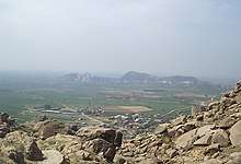
The Valley of Peshawar (Pashto: د لوی پېښور وادي; Urdu: وادئ پشاور) or Greater Peshawar is a broad valley situated in the central part of the Khyber Pakhtunkhwa province of Pakistan. The valley is 7,176 km2 (2,771 sq mi) in area, and is traversed by the Kabul River. It has a mean elevation of 345 metres (1,132 ft).[1] The valley takes its name from the city of Peshawar, which is situated at the western part of the valley close to Warsak Dam. To the west of the valley lies the Khyber Pass. The five most populous cities in the valley are Peshawar, Mardan, Swabi, Charsadda, and Nowshera.
The Peshawar Circular Railway project has been proposed to more closely interconnect the various towns of the valley.
Districts located in the valley
These districts of Khyber Pakhtunkhwa are completely located in the Valley of Peshawar:
- Charsadda District (population: 1,616,198)[2]
- Mardan District (population: 2,373,061)
- Peshawar District (population: 4,269,079)
In addition, most of Nowshera District, most of Swabi District, and smaller portions of Khyber (including Jamrud), Mohmand, Malakand, and Frontier Region Peshawar are also located in the Valley of Peshawar.
References
- Samad, Rafi U. (2011). The Grandeur of Gandhara: The Ancient Buddhist Civilization of the Swat, Peshawar, Kabul and Indus Valleys. Algora Publishing. ISBN 9780875868585. Retrieved 24 March 2017.
- "DISTRICT AND TEHSIL LEVEL POPULATION SUMMARY WITH REGION BREAKUP: KHYBER PAKHTUNKHWA" (PDF). Pakistan Bureau of Statistics. 2018-01-03. Retrieved 2018-04-23.