Utwa Ma
Utwa Ma is the capital of Utwa, a municipality in the Micronesian state of Kosrae.
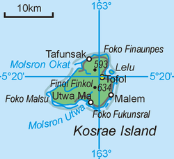
Map of Kosrae, showing Utwa Ma's location.
'Utwa Ma' is Kosraean for Utwa Village. The village itself is the largest village in Utwa, and lies close to the mouth of the Finkol River.
Climate
| Climate data for Utwa Ma | |||||||||||||
|---|---|---|---|---|---|---|---|---|---|---|---|---|---|
| Month | Jan | Feb | Mar | Apr | May | Jun | Jul | Aug | Sep | Oct | Nov | Dec | Year |
| Average high °C (°F) | 30.1 (86.1) |
30.3 (86.6) |
30.2 (86.3) |
30.5 (86.9) |
30.4 (86.7) |
31 (87) |
31 (87) |
30.6 (87.1) |
30.8 (87.4) |
30.6 (87.1) |
30.2 (86.4) |
30.4 (86.7) |
30.4 (86.8) |
| Average low °C (°F) | 23.9 (75.1) |
24.3 (75.7) |
24.1 (75.4) |
24.2 (75.6) |
24.1 (75.3) |
23.7 (74.7) |
24 (75) |
24.0 (75.2) |
24.1 (75.3) |
24.1 (75.4) |
24 (75) |
24.1 (75.3) |
24.1 (75.3) |
| Average precipitation mm (inches) | 440 (17.3) |
330 (12.8) |
400 (15.9) |
520 (20.3) |
430 (17) |
420 (16.4) |
380 (14.9) |
370 (14.4) |
380 (15.1) |
330 (12.8) |
370 (14.7) |
440 (17.4) |
4,800 (189) |
| Source: Weatherbase [1] | |||||||||||||
gollark: Of course, the index will be destroyed when I move this off my development computer onto the TRUE server.
gollark: ubqindexization™.
gollark: μhahahaha.
gollark: user interface™
gollark: Well, it needs to maintain a list of all the tokens in it to actually search it.
References
- "Weatherbase: Historical Weather for Utwa Ma, Federated States of Micronesia". Weatherbase. 2011. Retrieved November 24, 2011.
This article is issued from Wikipedia. The text is licensed under Creative Commons - Attribution - Sharealike. Additional terms may apply for the media files.