Utah State Route 19
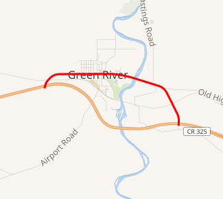
State Route 19 (SR-19) is a state highway in southeastern Utah, running 4.552 miles (7.326 km) in Emery and Grand Counties through Green River. It carries Business Loop I-70 along Main Street in Green River.
| ||||
|---|---|---|---|---|
| I-70 Business | ||||

SR-19 highlighted in red | ||||
| Route information | ||||
| Defined by Utah Code §72-4-107 | ||||
| Length | 4.552 mi[1] (7.326 km) | |||
| Existed | 1969–present | |||
| Major junctions | ||||
| West end | ||||
| East end | ||||
| Highway system | ||||
| ||||
Route description
SR-19 begins at an interchange with I-70 west of Green River, then heads east through the center of town and turns south through the Utah Launch Complex of White Sands Missile Range. It ends at a frontage road just south of another intersection with I-70.[1]
History
.jpg)
The main road through Green River was added to the state highway system in 1912,[2] and numbered as part of US-50 in the 1920s.[3] The state legislature defined the portion through Green River as State Route 19 in 1969, although the bypass on I-70 had not yet been built.[4] Construction had begun in the mid-1980s, and when finished, the old route, along with a new connection to exit 164, became SR-19.[5]
Major intersections
The entire route is in Green River.
| County | mi[1] | km | Destinations | Notes | |
|---|---|---|---|---|---|
| Emery | 0.000– 0.133 | 0.000– 0.214 | Western terminus; I-70 exit 160 | ||
| Grand | 4.449– 4.528 | 7.160– 7.287 | Eastern terminus; I-70 exit 164 | ||
| 1.000 mi = 1.609 km; 1.000 km = 0.621 mi | |||||
See also
References
- UDOT Highway Reference, SR-19
- Utah Department of Transportation, Highway Resolutions: "Route 8". (16.8 MB), updated September 2007, accessed May 2008
- Rand McNally Auto Road Atlas, 1926
- Utah Department of Transportation, State Route History Archived 2007-02-25 at the Wayback Machine, accessed July 2007
- Official Highway Map - Utah Transportation Commission (Map). 1 inch = 17.4 miles. Utah Department of Transportation. 1983. § G7.

