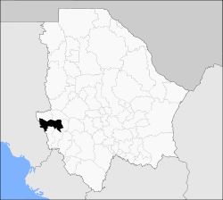
Uruachi Municipality
Uruachi is one of the 67 municipalities of Chihuahua, in northern Mexico. The municipal seat lies at Uruachi. The municipality covers an area of 3,058.31 km2.
Uruachi | |
|---|---|
 Municipality of Uruachi in Chihuahua | |
 Uruachi Location in Mexico | |
| Coordinates: 27°52′02″N 108°12′57″W | |
| Country | |
| State | Chihuahua |
| Municipal seat | Uruachi |
| Founded | November 21, 1844 |
| Area | |
| • Total | 3,058.31 km2 (1,180.82 sq mi) |
| Population (2010) | |
| • Total | 8,200 |
| • Density | 2.7/km2 (6.9/sq mi) |
As of 2010, the municipality had a total population of 8,200,[1] up from 7,934 as of 2005.[2]
As of 2010, the town of Uruachi had a population of 1,199.[1] Other than the town of Uruachi, the municipality had 422 localities, none of which had a population over 1,000.[1]
Geography
Towns and villages
The municipality has 268 localities. The largest are:
| Name | Population (2005) |
|---|---|
| Uruachi | 806 |
| Gasogachi | 316 |
| El Rebaje | 248 |
| Jicamorachi | 240 |
| Arechuyvo | 210 |
| Total Municipio | 7,934 |
gollark: I'm not sure if it's that they're written to the tapes that way, or whether my code for determining the end of a track is a bit broken.
gollark: There's a weird issue where tracks cut off slightly early and I have no idea why, though. Better figure that out.
gollark: Is the label not limited in length?
gollark: Great!
gollark: ,,,,,,,,,, ← brain DoS attack
References
- "Uruachi". Catálogo de Localidades. Secretaría de Desarrollo Social (SEDESOL). Retrieved 23 April 2014.
- "Uruachi". Enciclopedia de los Municipios de México. Instituto Nacional para el Federalismo y el Desarrollo Municipal. Archived from the original on February 23, 2007. Retrieved October 25, 2008.
This article is issued from Wikipedia. The text is licensed under Creative Commons - Attribution - Sharealike. Additional terms may apply for the media files.
