Urara Island
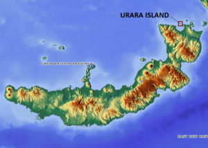
Urara Island is a small inhabited island in the northern part of Ataliklikun Bay (Bismarck Sea) in Papua New Guinea, located just off the mainland of the northern coast of New Britain. There are 3 villages, the largest lying on the southern central part of the coastline. Urara Island lies about 3 miles westward of Cape Liguan, and stands on a reef which extends a short distance only eastward of it and 1.5 miles to the westward.[1] Materbert Island lies about 6 miles west of the island and Watom Island lies to the north-east.[2]
References
- United States. Hydrographic Office (1916). Pacific islands pilot. Govt. Print. Off. p. 469. Retrieved 1 November 2011.
- Shaw, Norton; Galton, Sir Francis (1881). Proceedings ... Royal Geographical Society (Great Britain). pp. 92–3. Retrieved 1 November 2011.
This article is issued from Wikipedia. The text is licensed under Creative Commons - Attribution - Sharealike. Additional terms may apply for the media files.