Uden-Veghel
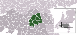
Uden-Veghel is a polycentric metropolitan area, centred on the towns of Uden and Veghel, in the east of the province of North Brabant in the southern Netherlands. It consists of the neighbouring municipalities of Uden and Veghel with the surrounding municipalities of Schijndel, Sint-Oedenrode, Bernheze, Landerd and Boekel.
Uden-Veghel | |
|---|---|
Metropolitan region | |
| Stedelijke regio Uden-Veghel | |
 | |
| Coordinates: 51°38′17″N 5°34′09″E | |
| Country | |
| Province | |
| Largest towns | Uden Veghel |
| Other municipalities | Schijndel, Sint-Oedenrode, Bernheze, Landerd, Boekel |
| Area | |
| • Metro region | 428.04 km2 (165.27 sq mi) |
| • Land | 425.21 km2 (164.17 sq mi) |
| • Water | 2.83 km2 (1.09 sq mi) |
| • Urban | 40.58 km2 (15.67 sq mi) |
| Population | |
| • Metro region | 161,900 |
| • Density | 381/km2 (990/sq mi) |
| • Urban | 94,215 |
| • Urban density | 2,322/km2 (6,010/sq mi) |
.jpg)
The province of North Brabant established the partnership in 2002 for spatial planning purposes, and stated that the municipalities of Uden and Veghel are complementary to each other. The agreement included zoning plans for the development of residential, business and industrial areas, as well as plans for the development and preservation of nature in the region.
The provincie of North Brabant defines the chain of Schijndel-Eerde-Veghel and Uden-Volkel as highly urbanized. The municipalities of Sint-Oedenrode and Landerd are described as being moderately urbanized, and Erp, Boekel and Bernheze are considered to be rural.
| Population figures and facts of Uden-Veghel (2010) | |||
|---|---|---|---|
| Municipality | Population | Jobs | Companies |
| Uden | 40,536 | 22,221 | 2,900 |
| Veghel | 37,303 | 28,602 | 2,727 |
| Schijndel | 22,991 | 10,041 | 1,738 |
| Sint-Oedenrode | 17,680 | 5,997 | 1,403 |
| Bernheze | 29,655 | 10,168 | 2,150 |
| Landerd | 14,888 | 6,233 | 1,117 |
| Boekel | 9,772 | 3,925 | 802 |
| Total: | 172,825 | 79,638 | 12,837 |
(source: CBS, Gemeente op Maat)
_Cropped.jpg)
Notes
- Uden–Veghel–Schijndel urban area
Combined built-up area of Uden, Veghel and Schijndel, with adjacent commuter towns and business parks, forming a continuous urban and industrially developed area. The outer rural areas aren't included.
References
- "Kerncijfers wijken en buurten 2014" [Key figures for neighbourhoods 2014]. CBS Statline; Metro region (in Dutch). CBS. 1 January 2014. Retrieved 2 September 2015.
- "Kerncijfers wijken en buurten 2010" [Key figures for neighbourhoods 2010]. CBS Statline; Urban area (in Dutch). CBS. 1 January 2010. Retrieved 10 December 2014.