Ubbergen
Ubbergen (![]()
Ubbergen | |
|---|---|
Town and former municipality | |
 Church in Beek | |
 Flag  Coat of arms | |
.svg.png) Location in Gelderland | |
| Coordinates: 51°50′N 5°55′E | |
| Country | Netherlands |
| Province | Gelderland |
| Municipality | Berg en Dal |
| Area | |
| • Total | 38.88 km2 (15.01 sq mi) |
| • Land | 33.77 km2 (13.04 sq mi) |
| • Water | 5.11 km2 (1.97 sq mi) |
| Elevation | 13 m (43 ft) |
| Population (January 2019)[3] | |
| • Total | data missing |
| Demonym(s) | Ubberger |
| Time zone | UTC+1 (CET) |
| • Summer (DST) | UTC+2 (CEST) |
| Postcode | 6570–6579 |
| Area code | 024 |
| Website | www |
Gallery
 Ubbergen, monastery: complex de Refter
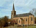 Kekerdom, church
 Persingen, church
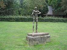 Statue of Nescio
gollark: It's possible, but probably not.
gollark: Probably.
gollark: Well, I'd like it to predict more interesting stuff than "lol" and stuff.
gollark: What if we run GPT-2 or whatever over esolangs pages? Hmm.
gollark: Which is impractical.
References
- "Kerncijfers wijken en buurten" [Key figures for neighbourhoods]. CBS Statline (in Dutch). CBS. 2 July 2013. Retrieved 12 March 2014.
- "Postcodetool for 6573CL". Actueel Hoogtebestand Nederland (in Dutch). Het Waterschapshuis. Retrieved 18 July 2014.
- "Bevolkingsontwikkeling; regio per maand" [Population growth; regions per month]. CBS Statline (in Dutch). CBS. 1 January 2019. Retrieved 1 January 2019.
This article is issued from Wikipedia. The text is licensed under Creative Commons - Attribution - Sharealike. Additional terms may apply for the media files.