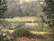
Ty-asch, Mamhilad
Ty-asch, Mamhilad, Monmouthshire is a farmhouse dating from the late 16th century. Largely unaltered since its construction, Ty-asch is a Grade II* listed building.
| Ty-asch | |
|---|---|
 "extraordinarily unaltered" | |
| Type | Farmhouse |
| Location | Mamhilad, Monmouthshire |
| Coordinates | 51.7255°N 3.0158°W |
| Built | late 16th century |
| Architectural style(s) | Vernacular |
| Governing body | Privately owned |
Listed Building – Grade II* | |
| Official name: Ty-asch | |
| Designated | 18 July 2001 |
| Reference no. | 25578 |
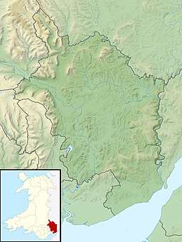 Location of Ty-asch in Monmouthshire | |
History and description
The farmhouse dates from the late 16th century and is constructed to a two-cell plan.[1] By 1650, a bakehouse had been built adjacent to the main structure.[2] In the 19th century, the windows were replaced with Victorian casements. The farmhouse of a working farm until the 1930s, at which point it was put to use as a cow shelter, the building has been unaltered since that time. Converted back to residential use in the 21st century, it remains a private home.[3][4] The house is not mentioned in John Newman's Gwent/Monmouthshire Pevsner, its listing in 2001 post-dating the publication. A Grade II* listed building, its listing record describes Ty-asch as "extraordinarily unaltered".[1]
Notes
- Cadw. "Ty-asch (Grade II*) (25578)". National Historic Assets of Wales. Retrieved 10 March 2020.
- "Ty'r Asch, Mamhilad, Pontypool". coflein.gov.uk. Coflein. Retrieved 10 March 2020.
- Foster, Peter (May 23, 2002). "Run-down cow shed turns out to be Tudor treasure". Daily Telegraph – via www.telegraph.co.uk.
- "Ty Asch Farm". www.tyaschfarm.co.uk. Retrieved 10 March 2020.