Turkey Run (West Branch Susquehanna River tributary)
Turkey Run is a tributary of the West Branch Susquehanna River in Lycoming County, Pennsylvania, in the United States. It is approximately 2.2 miles (3.5 km) long and flows through Clinton Township.[1] The watershed of the stream has an area of 2.18 square miles (5.6 km2). The stream is not designated as an impaired waterbody. It is a relatively small stream and is located near State Correctional Institution – Muncy. The stream's watershed is designated as a Warmwater Fishery and a Migratory Fishery.
| Turkey Run | |
|---|---|
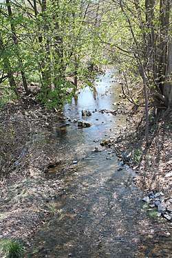 Turkey Run looking downstream | |
| Physical characteristics | |
| Source | |
| • location | base of a large mountain in Clinton Township, Lycoming County, Pennsylvania |
| • elevation | 596 ft (182 m) |
| Mouth | |
• location | West Branch Susquehanna River in Clinton Township, Lycoming County, Pennsylvania near Seagers |
• coordinates | 41°10′56″N 76°49′08″W |
• elevation | 459 ft (140 m) |
| Length | 2.2 mi (3.5 km) |
| Basin size | 2.18 sq mi (5.6 km2) |
| Basin features | |
| Progression | West Branch Susquehanna River → Susquehanna River → Chesapeake Bay |
Course
Turkey Run begins at the base of a large mountain in Clinton Township. It flows east for a few tenths of a mile before turning south and passing through a small pond. After a few tenths of a mile, the stream turns southeast for several tenths of a mile, passing through another small pond, crossing Pennsylvania Route 405, and crossing railroad tracks. It then turns south-southwest for several tenths of a mile before reaching its confluence with the West Branch Susquehanna River.[1]
Turkey Run joins the West Branch Susquehanna River 25.64 miles (41.26 km) upstream of its mouth.[2]
Hydrology
Turkey Run is not designated as an impaired waterbody.[3]
Geography and geology
The elevation near the mouth of Turkey Run is 459 feet (140 m) above sea level.[4] The elevation of the stream's source is 596 feet (182 m) above sea level.[1]
Turkey Run was described as a "small stream" in an 1892 book of Lycoming County history.[5] The stream is in a region known as the Black Hole Valley, along with Black Hole Creek.[6]
Watershed
The watershed of Turkey Run has an area of 2.18 square miles (5.6 km2).[2] The stream is entirely within the United States Geological Survey quadrangle of Muncy.[4] Its mouth is located within 1 mile (1.6 km) of Seagers.[2]
The designated use for Turkey Run is aquatic life.[3] The stream is not far from Williamsport, but is on the opposite bank of the West Branch Susquehanna River.[7] The State Correctional Institution Muncy is located near the headwaters of Turkey Run.[8]
History
Turkey Run was entered into the Geographic Names Information System on August 2, 1979. Its identifier in the Geographic Names Information System is 1189947.[4]
Peter Smith had a farm on Turkey Run by 1778. His wife and children were killed in July 1778. In August of that year, a group of soldiers and militia were sent to the farm to protect people helping Smith harvest his crop.[7] Turkey Run provided power to gristmills and sawmills in the early days of settlement in the stream's vicinity.[6]
A bridge carrying Pennsylvania Route 405 crosses Turkey Run. In 2013, an $85,000 bridge replacement was planned for 2014 to 2016.[9] Turkey Run Partners once applied for and/or received a National Pollutant Discharge Elimination System permit to discharge stormwater into the stream during construction activities.[10]
Biology
The drainage basin of Turkey Run is designated as a Warmwater Fishery and a Migratory Fishery.[11] In the 1970s, the stream was described as being "moderately depressed" downstream of the State Correctional Institute Muncy.[8]
See also
- Black Hole Creek, next tributary of the West Branch Susquehanna River going downriver
- Glade Run, next tributary of the West Branch Susquehanna River going upriver
- List of rivers of Pennsylvania
References
- United States Geological Survey, The National Map Viewer, retrieved January 17, 2016
- Pennsylvania Gazetteer of Streams (PDF), November 2, 2001, retrieved January 17, 2016
- United States Environmental Protection Agency, 2006 Waterbody Report for Turkey Run, retrieved January 17, 2016
- Geographic Names Information System, Feature Detail Report for: Turkey Run, retrieved January 17, 2016
- John Franklin Meginness, ed. (1892), History of Lycoming County, Pennsylvania, p. 585
- Full text of The One-room school: Lycoming County's legacy, retrieved January 17, 2016
- William W. Betts, Jr. (2010), The Hatchet and the Plow: The Life and Times of Chief Cornplanter, p. 42, ISBN 9781450267151
- Pennsylvania. Bureau of Water Quality Management, Edward R. Brezina (1974), A Listing of Aquatic Biological Stream Investigations: June, 1968 to January, 1974, p. 41
- Lycoming County Planning and Community Development, Williamsport Area Transportation Study Metropolitan Planning Organization 2013–2033 Long Range Transportation Plan Executive Summary (PDF), retrieved January 17, 2016
- "Actions", Pennsylvania Bulletin, retrieved January 17, 2016
- "§ 93.9l. Drainage List L. Susquehanna River Basin in Pennsylvania West Branch Susquehanna River", Pennsylvania Code, retrieved January 17, 2016