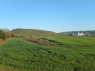
Tulare Hill
Tulare Hill is a prominent hill in the Santa Teresa Hills of western Santa Clara County, California. It lies along the southernmost edge of San Jose, California, adjacent to the Metcalf Energy Center. The hill and surrounding 330 acres (130 ha) of serpentine grasslands are home to the endangered Bay checkerspot butterfly[3] and Dudleya setchellii wildflower.[4]
| Tulare Hill | |
|---|---|
 Tulare Hill along Santa Teresa Boulevard | |
| Highest point | |
| Elevation | 620 ft (190 m) NGVD 29[1] |
| Prominence | 320 ft (98 m) NGVD 29[1] |
| Coordinates | 37°13′16″N 121°45′18″W [2] |
| Geography | |
 Tulare Hill Location in California | |
| Location | Santa Clara County, California, U.S. |
| Parent range | Santa Teresa Hills |
| Topo map | USGS Tulare Hill |
Geography
The hill sits atop the narrowest gap between the Santa Cruz and Diablo mountain ranges, and overlooks the Laguna Seca wetlands in northern Coyote Valley.[5]
History
The hill was once part of the historic Rancho Santa Teresa and Rancho Laguna Seca lands granted in the early 1800s.
Wildfires
In August 2019, a brush fire consumed approximately 60 acres along the southwestern part of the hill, as well as a small area on the eastern side of nearby Santa Teresa County Park.[6]
References
- "Tulare Hill". ListsOfJohn.com. Retrieved 2014-03-08.
- "Tulare Hill". Geographic Names Information System. United States Geological Survey. Retrieved 2013-04-24.
- PG&E Newsletter, March 2013
- Silicon Valley Land Conservancy Newsletter, Summer 2008
- Open Space Authority, Coyote Valley Landscape Linkage, December 2017
- CalFire, Bayliss Fire, August 2019