Truss's Island
Truss's Island is a small island in the River Thames in England, between Staines-upon-Thames and Laleham. The uninhabited island is publicly accessible across two footbridges from the right (western) bank of the Thames and is landscaped with grass, trees and shrubs.

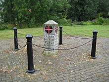
Inscribed stone erected by the City of London in 1804 to thank Charles Truss for 30 years' service in maintaining the navigability of the river
History
The island was named after Charles Truss, who improved the navigation of this section of the Thames while working for the City of London in the late 18th century.[1]
gollark: It's not a proof of concept, it's an ideæ. You should implement it and see.
gollark: "Your credit is good so we can loan you 9282717278 credits"
gollark: "We've credited your account with a credit of 3 credits"
gollark: "Hmm, yes, I'll use my credit card to pay someone with my credits"
gollark: It would be very confusing.
See also
References
- 'Exploring the Thames Wilderness: Truss's Island' Archived 22 December 2015 at the Wayback Machine
| Wikimedia Commons has media related to Truss's Island. |
| Next island upstream | River Thames | Next island downstream |
| Church Island | Truss's Island | Penton Hook Island |
This article is issued from Wikipedia. The text is licensed under Creative Commons - Attribution - Sharealike. Additional terms may apply for the media files.