Psofida
Psofida (Greek: Ψωφίδα) is a village and a community in the municipal unit of Aroania in the southern part of Achaea, Greece. The community consists of the villages Psofida, Ano Psofida, Tripotama, Ano Tripotama, Kato Tripotama and Vasiliki. Psofida was named after the ancient Arcadian town Psophis, that was located near the present village Tripotama. It is situated near the confluence of the rivers Erymanthos, Aroanios and Seiraios, and near the tripoint of Achaea, Arcadia and Elis. It is 4 km southwest of Livartzi, 9 km east of Lampeia, 25 km southwest of Kalavryta and 45 km southeast of Patras. The Greek National Road 33 (Patras - Tripoli) passes through Tripotama.
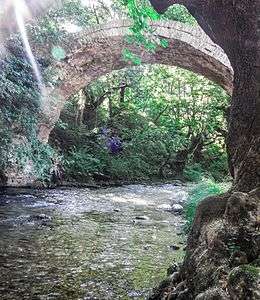
Erymanthos River and the old arched stone bridge in Tripotama village, Achaia-Ilia borders.
Psofida Ψωφίδα | |
|---|---|
 Psofida | |
| Coordinates: 37°52′N 21°54′E | |
| Country | Greece |
| Administrative region | West Greece |
| Regional unit | Achaea |
| Municipality | Kalavryta |
| Municipal unit | Aroania |
| Elevation | 570 m (1,870 ft) |
| Population (2011)[1] | |
| • Rural | 32 |
| Community | |
| • Population | 279 (2011) |
| Time zone | UTC+2 (EET) |
| • Summer (DST) | UTC+3 (EEST) |
| Postal code | 250 12 |
| Area code(s) | 26920 |
Historical population
| Year | Population |
|---|---|
| 1981 | 434 |
| 2001 | 360 |
| 2011 | 279 |
gollark: Why should I be FORCED to experience 9.81N/kg of downward force?!
gollark: Really, we're enslaved by reality and its ridiculous constraints.
gollark: Okay, that's possibly justifiable.
gollark: Oh, I read the end of that as "I think".
gollark: Have you SEEN slaves?
See also
References
- "Απογραφή Πληθυσμού - Κατοικιών 2011. ΜΟΝΙΜΟΣ Πληθυσμός" (in Greek). Hellenic Statistical Authority.
This article is issued from Wikipedia. The text is licensed under Creative Commons - Attribution - Sharealike. Additional terms may apply for the media files.