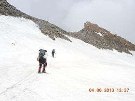
Traill's Pass
Pindari Kanda Traill's Pass (el. 5,300 m or 17,400 ft) is a mountain pass through the Himalayas located between Nanda Devi and Nanda Kot peaks[1] in the Uttarakhand state in the districts of Pithoragarh and Bageshwar in India.
| Trail's Pass | |
|---|---|
 | |
| Elevation | 5,312 m (17,428 ft) |
| Location | India |
| Range | Himalaya |
| Coordinates | 30°19′10″N 80°01′40″E |
It is situated at the end of Pindari glacier and links Pindari valley to Milam valley (Lawan Gad) and is said to be very difficult to cross. The pass was reached in 1830 by G.W. Traill, the first British Deputy Commissioner of Kumaon division. In 1926, it was crossed by Hugh Ruttledge.[2]
People from Johar Valley and Pindar Valley attempted to cross it for trade. Budha Malak Singh of Supi village of Bageshwar District of Uttarakhand State was the first man to cross it 1830 after 100 years. Later Mr. Trail also attempted to cross the pass but failed, though the pass was since then named as Trail’s Pass, earlier it was called "Pindari Kanda". Trail's Pass (el. 5,312 m) is a mountain pass through the Himalayas located between the unnamed southern shoulder of Mt. Nanda Devi East and Changuch (Western shoulder of Mt.Nanda Kot) peaks in Uttarakhand state in the districts of Bageshwar and Pithoragarh. It is situated at the head of Pindari glacier and Trails pass bridges Pindari Valley with LwanValley (Nandadevi East Base camp) and is said to be very difficult to cross. Though Pindari glacier is visited by many people every year, yet Trail’s Pass, which is at its top remains an elusive goal.
By Himalayan standards, the Pindari glacier and the Trail’s Pass do not match most of the giants. The Pindari is neither the largest nor the longest of the glaciers nor is the Trail’s Pass, at its head, the highest of passes. However, Pindari has been the most frequently visited Himalayan glacier since the mid-19th century when a bridle-path with dak bungalows at suitable intervals between there and Almora was built. Even today, it is so popular a trekking destination that a tenfold increase in the number of beds available is unable to cope with the influx.
What faces a visitor to Pindari glacier at the Zero Point, along its left lateral moraine, is an immense wall of jagged, broken ice criss¬crossed with thousands of seracs and crevasses. The upper icefields of the glacier are invisible from there and the near level ice mass at its lower end at the snout below recedes into insignificance. What people call the Pindari glacier is actually a huge icefall passing over a steep slope, through which a direct ascent has yet to be made. Above this lie the icefields of the surrounding heights and the névé basin of the glacier, some 8 km long, separated from the ridge above with a text-book fashion bergschrund. The lowest point on the ridge at 5312 m is the Trail’s Pass. Beyond the pass to the north and east lies the Lwan valley whose catchment is the Gori ganga valley.
Pindar river which forms the main tributary of river Alaknanda which further joins the Bhagirathi to form The Ganges at Dev Prayag.
Since 1830, Trail’s pass has been attempted by more than 90 teams, till now only 18 teams are known to have attained success.
Teams are listed below:
SNO. YEAR TEAM
1 1830 Malak Singh, Supi, Bageshwar.
2 1855 Adolf Schlagintweit
3 1861 Captain Ed Smyth
4 1899 Kurt Buch
5 1926 Hughe Ruttledge with wife
6 1930 Hughe Stenlorge
7 1931 Devan Singh Martolia
8 1936 August Gansser
9 1941 S.S. khera
10 1994 Nainital Mountaineering Club Nanital.
11 2009 Martin Moran, England June
12 2009 Basanta Singha Roy along with 3 members and 4 Sherpas of Mountaineers' Association of Krishnanagar crossed Trail's Pass on 30th August, 2009 http://www.mak.org.in
13 2009 Bhadreswar Pathfinder Adventurers (in Sept.)
14 2013 Himalpinist -Dhruv Joshi, Bharat Bhushan & Vineet kumar Saini (MAY-JUNE) first smallest team so far http://www.himalpinist.com
15 2015 Dhruv Joshi, Ulrich - Karen Rauner (SEPT-OCT)
16 2016 HITAM (Himalaya trekkers and mountaineer) largest group till date (12-members, 11- porters) (sept-oct)
17 2017 Major Chirag Chatterjee and team , Indian Army. (6 members) (SEPT)[3][4]
18 2017 Himalpinist-Dhruv Joshi, Narendra Kumar, Ravi Bangera, Prashant Sawant, Aberrant Wanderers - Sanket Patil (youngest till date) (Sept-Oct) second smallest team [5]
19 2019-September: Tanmoy Dam,Bidyut Das,Ashis Das,Siddheswar Khearu,Sankar Sarkar,Rahul Guha,Sayantan Dutta and Monojit Basu, we are 8 members successfully cross the pass without any health issues.
Dawa and Tengin Sherpa support us .Rupsingh Ji and Mohon guide us of trail’s pass trek.
Note- “jumering and rappel down is very hard for rock fall of trail’s pass.rope(700-800 meter) and rock piton is More needed .September mid is preferable time for trail’s pass. It’s a challenging trek. -Tanmoy Dam”
Footnotes
- Kapadia, Harish (1 January 1999). Across Peaks and Passes in Garhwal Himalaya. India: Indus Publishing Company. p. 57. ISBN 978-81-7387-097-2. Retrieved 5 August 2009.
- Kapadia, Harish (1 January 1999). Across Peaks and Passes in Garhwal Himalaya. India: Indus Publishing Company. pp. 59–60. ISBN 978-81-7387-097-2. Retrieved 5 August 2009.
- "ट्रेल पास फतह कर लौटे पर्वतारोही". mepaper.livehindustan.com. Retrieved 24 September 2017.
- "सेना के जवानों ने ट्रेल पास पर तिरंगा फहराया- Amarujala". Amar Ujala. Retrieved 24 September 2017.
- http://mepaper.livehindustan.com/pagezoomsinwindows.php?id=2278178&boxid=115670302&cid=4&mod=&pagenum=10&edcode=303&pgdates=2017-10-13
[[Category:Geography of Pithoragarh district]] https://mak.org.in