Trabuco Peak
Trabuco Peak is a 4,607-foot (1,404 m) summit in the Santa Ana Mountains on the border of Orange and Riverside Counties, California, about halfway between Rancho Santa Margarita and Lake Elsinore.[2] The mountain sits on the divide between Arroyo Trabuco (Trabuco Canyon) on the west and the Temescal Creek valley on the east. Situated in the Cleveland National Forest, it is the highest summit in the Santa Anas south of Santiago Peak.[3][4]
| Trabuco Peak | |
|---|---|
| Highest point | |
| Elevation | 4,607 ft (1,404 m) NAVD 88[1] |
| Prominence | 817 ft (249 m) [1] |
| Parent peak | Santiago Peak |
| Listing | Sierra Club Lower Peaks Section |
| Coordinates | 33°42′08″N 117°28′30″W |
| Geography | |
| Location | Orange/Riverside Counties, California |
| Parent range | Santa Ana Mountains |
| Topo map | USGS Alberhill[2] |
| Climbing | |
| Easiest route | Hike |
The main trails providing access to the peak, the West Horsethief and Holy Jim trails, both begin at the bottom of Trabuco Canyon. The Main Divide Road, a fire road, also passes close to the peak.[2]
References
- "Trabuco Peak, California". Peakbagger.com. Retrieved 2014-03-08.
- "Trabuco Peak". Geographic Names Information System. United States Geological Survey. 1981-01-19. Retrieved 2013-12-14.
- USGS Topo Maps for United States (Map). Cartography by United States Geological Survey. ACME Mapper. Retrieved 2013-12-14.
- Wood, Alex (2010-02-08). "Trabuco Peak". SummitPost. Retrieved 2013-12-14.
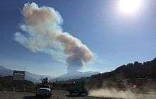
Wildfire near Holy Jim trail, 2016, Cleveland NF
This article is issued from Wikipedia. The text is licensed under Creative Commons - Attribution - Sharealike. Additional terms may apply for the media files.