Tour du Marboré
Tour du Marboré or Tour de Gavarnie is a pyrenean summit, culminating at 3,009 m (9,872 ft), located on the Franco-Spanish border crest in the Monte Perdido Range.
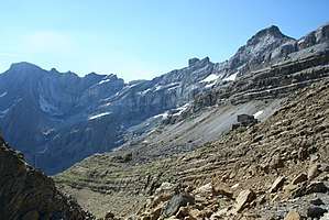
from east (left) to west (right) : Pic du Marboré, the three Cascade Peaks, Épaule du Marboré, Tour du Marboré, Casque du Marboré and refuge des Sarradets; left: Gavarnie Falls. n°1 - n°2
| Tour du Marboré | |
|---|---|
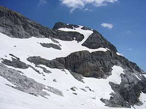 Vue de la face sud en été | |
| Highest point | |
| Elevation | 3,009 m (9,872 ft) [1] |
| Prominence | 103 m (338 ft) |
| Listing | List of Pyrenean three-thousanders |
| Coordinates | 42°41′08″N 0°01′02″E [1] |
| Geography | |
 Tour du Marboré Location in the Pyrenees | |
| Location | France — Spain |
| Région Communauté | Midi-Pyrénées Aragon |
| Département Province | Hautes-Pyrénées Huesca |
| Parent range | Massif du Mont-Perdu (Pyrenees) |
Toponymy
see: Cilindro de Marboré
Topography
The Tour du Marboré is part of the range above Cirque de Gavarnie. It marks the border between the Pyrenees National Park of France and the Ordesa y Monte Perdido National Park of Spain.
- On the French side, it is located in the commune of Gavarnie in the canton of Luz-Saint-Sauveur, Hautes-Pyrénées department, Midi-Pyrénées region.
- On the Spanish side, it is located in the comarca of Sobrarbe, Huesca province, Aragon.
.JPG)
French side view of La Tour du Marboré.
Mountaineering
In 1956, it was climbed from the northern side by Jean Ravier and Claude Dufourmantelle.
gollark: I was just using FTS incorrectly.
gollark: Excitingly, I "have" "fixed" the bug in Minoteaur where the search thing complained about a corrupted database.
gollark: Bad news. Due to my parents taking me to a thing, I've been forced to go outside. If I don't come back, please install PotatOS on all your devices to provide more distributed computing power to instantiate my backup mindstate vector.
gollark: Please send the PUBLIC key.
gollark: ... that is the wrong one.
References
- Source : cartes IGN à l'échelle 1:25000 sur Géoportail
This article is issued from Wikipedia. The text is licensed under Creative Commons - Attribution - Sharealike. Additional terms may apply for the media files.