Tok Airport
Tok Airport (IATA: TKJ, ICAO: PATJ, FAA LID: TKJ) was a state-owned public-use airport located two nautical miles (4 km) south of the central business district of Tok,[1] in the Southeast Fairbanks Census Area of the U.S. state of Alaska.
Tok Airport | |||||||||||
|---|---|---|---|---|---|---|---|---|---|---|---|
 | |||||||||||
| Summary | |||||||||||
| Airport type | Public | ||||||||||
| Owner | Alaska DOT&PF - Northern Region | ||||||||||
| Serves | Tok, Alaska | ||||||||||
| Elevation AMSL | 1,670 ft / 509 m | ||||||||||
| Coordinates | 63°18′12″N 143°00′04″W | ||||||||||
| Runways | |||||||||||
| |||||||||||
| Statistics (2005) | |||||||||||
| |||||||||||
Facilities and aircraft
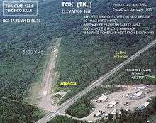
Tok Airport has one runway designated 13/31 with a 1,690 by 45 ft (515 x 14 m) gravel and turf surface.[2] For the 12-month period ending December 31, 2005, the airport had 600 aircraft operations, an average of 50 per month: 83% general aviation and 17% air taxi. At that time there were 17 aircraft based at this airport, all single-engine.[1]
Other airports in Tok
- Tok Junction Airport (IATA: TKJ, ICAO: PFTO, FAA LID: 6K8) is state-owned public-use located at 63°19′46″N 142°57′13″W, one nautical mile (2 km) east of the central business district of Tok. It has one runway designated 7/25 with a 2,509 x 50 ft (765 x 15 m) asphalt surface.[3]
- Tok 2 Airport (FAA LID: 8AK9) is a private-use airport located at 63°18′32″N 143°01′04″W, on the opposite side of Glenn Highway from the Tok Airport. It has one runway designated 10/28 with a 2,035 x 80 ft (620 x 24 m) gravel surface.[4]
gollark: Most gods are generally mostly biologically immortal and cannot really get diseases.
gollark: Of course, this can be risky, because it could turn out that the real friends were the treasure you made along the way, and you would then have to quickly retrieve that to use this mechanism.
gollark: https://media.discordapp.net/attachments/461970193728667648/956259271874609172/image0-7.jpg
gollark: Here's an artist's impression.
gollark: The power of friendship could also be used.
References
- "Tok Airport (PATJ / TKJ) - FAA information effective 30 August 2007". FAA data republished by AirNav. Archived from the original on 14 September 2007.
- "Annotated aerial photo of Tok (TKJ)". Federal Aviation Administration, Alaska Region. Summer 1975. Archived from the original (JPG) on 14 January 2009.
- FAA Airport Master Record for 6K8 (Form 5010 PDF). Federal Aviation Administration. effective 25 August 2011.
- FAA Airport Master Record for 8AK9 (Form 5010 PDF). Federal Aviation Administration. effective 25 August 2011.
External links
- Aerial photo of Tok (TKJ) and Tok 2 (8AK9) (JPG). Federal Aviation Administration, Alaska Region. Summer 1975.
- Airport diagram of Tok (TKJ) and Tok 2 (8AK9) (GIF). Federal Aviation Administration, Alaska Region. September 2004.
- Topographic map showing Tok and landing strip to the south. USGS The National Map via MSR Maps. July 1948.
- Accident history for TKJ at Aviation Safety Network
This article is issued from Wikipedia. The text is licensed under Creative Commons - Attribution - Sharealike. Additional terms may apply for the media files.