Tietkens expedition of 1889
The Tietkens expedition of 1889 was led by William Tietkens. It covered territory west of Alice Springs to the vicinity of the Western Australian border. [1]

Expedition members
The expedition members were:[2]
- David Beetson
- Fred Warman
- Billy (a black-tracker from the ranks of the native police at Alice Springs)
- A small native boy
Dates
The expedition took place from March to July 1889.[2]
Purpose and outcome
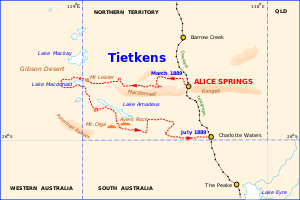
Tietkens hoped to discover a supply channel to Lake Amadeus from hills to the north-west, expecting that this might open a reliable route to the north-west coast settlements. He succeeded in proving that it did not exist.
Support
The South Australian branch of the Royal Geographical Society of Australasia was instrumental in mounting the expedition and appointing Tietkens as leader.
Discoveries
This expedition discovered Lake Macdonald, the Kintore Range, Mount Leisler, Mount Rennie, the Cleland Hills, defined the western borders of Lake Amadeus, and photographed Uluru (Ayers Rock) and Kata Tjuta (Mount Olga) for the first time.
Features named by Tietkens, with the source of the name, include:[2]
- Lake Macdonald, named for Mr A. C. Macdonald, the secretary of the Victorian branch of the Royal Geographical Society.
- Kintore Range, named for Lord Kintore, governor of South Australia.
- Mount Leisler, named for Louis Leisler, a financial supporter of Tietkens.
- Mount Rennie, named for Professor Rennie of Adelaide University.
- Cleland Hills, named for William Lennox Cleland, a South Australian doctor.
Route

The attached map shows the main features of the route followed.
Means of travel
The caravan consisted of twelve camels, sufficient to carry the expedition members, provisions for up to four months and water for a lesser period.[2]
Accomplishments
The expedition collected new species of plants and rock samples allowing the South Australian government geologist to compile a 'geological sketch' of the country traversed.
Specimens of 250 plant species were collected, although only 8 were new to science, [3] and in 1890, Ferdinand von Mueller and Ralph Tate named Eremophila tietkensii in his honour. [4] [5]
Publications
The following publications contain information derived from this expedition:
Recognition
. Tietkens was elected a fellow of the Royal Geographical Society on his return.
References
- Joy, William (1964). The Explorers. Adelaide: Rigby Ltd. p. 72. ISBN 0 85179 112 3.
- "Journal of the Central Australia Exploring Expedition".
- von Mueller, Ferdinand; Tate, Ralph (1890). "List of Plants collected during Mr. Tietkens' Expedition into Central Australia, 1889". Transactions and proceedings and report, Royal Society of South Australia. 13: 95. Retrieved 24 March 2016.
- Chinnock, R.J. (Bob) (2007). Eremophila and allied genera : a monograph of the plant family Myoporaceae (1st ed.). Dural, NSW: Rosenberg. pp. 425–427. ISBN 9781877058165.
- Brown, Andrew; Buirchell, Bevan (2011). A field guide to the eremophilas of Western Australia (1st ed.). Hamilton Hill, W.A.: Simon Nevill Publications. p. 275. ISBN 9780980348156.
External links
- Letter from David W. Carnegie to Tietkens (at Flinders University Library)