Thornsett
Thornsett is a hamlet within the civil parish of New Mills. It is between New Mills and Hayfield,[1] and features a primary school, a nursery, two pubs, a bandroom and a cemetery. It is roughly 13 miles (21 km) southest of central Manchester and 22 miles (35 km) west of Sheffield. The hamlet is governed by High Peak Borough Council and, as it lies within New Mills' parish boundaries, New Mills Town Council.
History

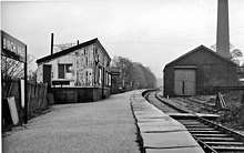
The hamlet was once served by a railway line (now the Sett Valley Trail) which ran from New Mills Central to Hayfield Station (now demolished), before the line was closed, due to lack of use, in 1970. The hamlet was served from the local Birch Vale Station.[2]
Until 2008, Birch Vale, and therefore Thornsett, was served by a post office, before it was closed.[3] The closest offices are now in Hayfield and New Mills.
Geography and transport
The hamlet is accessed only by local roads and has links to nearby New Mills, Rowarth, Mellor, Marple and Hayfield.[1]
The only bus route that runs through Thornsett is the High Peak 60[4], which runs to Hayfield and New Mills.

The nearest stations are New Mills Central and New Mills Newtown, with both having services to Manchester and Stockport, but also separately running to Buxton, Chesterfield and Sheffield.
The River Sett runs along the bottom of the hill, flowing from Kinder Scout to The Torrs in New Mills, where the river joins the River Goyt.
There were two chapels in the hamlet.[5]
References
- OL1 Dark Peak area (Map). 1:25000. Explorer. Ordnance Survey.
- Smith, Ian R; Fox, G K (2003). Manchester London Road to Hayfield: Scenes from The Past 45. Ian Allan Publishing. ISBN 1-870119-73-8.
- "Local views unheeded in post office closures". Buxton Advertiser. 15 August 2008. Retrieved 26 December 2019.
- "60 | High Peak". www.highpeakbuses.com. Retrieved 2020-07-26.
- "Thornsett, Derbyshire - genealogy heraldry and history". ukga.org. Retrieved 2019-12-26.