Thiat
Thiat (Occitan: Tiat) is a former commune in the Haute-Vienne department in the Nouvelle-Aquitaine region in west-central France. On 1 January 2019, it was merged into the new commune Val-d'Oire-et-Gartempe.[2]
Thiat | |
|---|---|
Part of Val-d'Oire-et-Gartempe | |
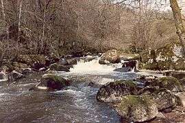 The Brame in winter | |
.svg.png) Coat of arms | |
Location of Thiat 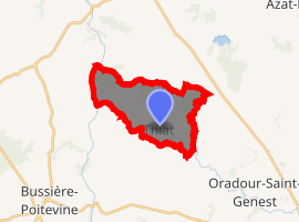
| |
 Thiat  Thiat | |
| Coordinates: 46°16′03″N 0°58′30″E | |
| Country | France |
| Region | Nouvelle-Aquitaine |
| Department | Haute-Vienne |
| Arrondissement | Bellac |
| Canton | Châteauponsac |
| Commune | Val-d'Oire-et-Gartempe |
| Area 1 | 11.35 km2 (4.38 sq mi) |
| Population (2017)[1] | 138 |
| • Density | 12/km2 (31/sq mi) |
| Time zone | UTC+01:00 (CET) |
| • Summer (DST) | UTC+02:00 (CEST) |
| Postal code | 87320 |
| Elevation | 123–226 m (404–741 ft) |
| 1 French Land Register data, which excludes lakes, ponds, glaciers > 1 km2 (0.386 sq mi or 247 acres) and river estuaries. | |
Geography
The river Brame forms all of the commune's southern border, then flows into the Gartempe, which forms all of its western border.
Demographics
Inhabitants are known as Thiachons.
gollark: Oh, JUST as I get scrcpy working my internet connection turns back on anyway.
gollark: Why's that an actual moral issue?
gollark: Hold on, I can hook my phone up to my computer keyboard if I can find the weird cables.
gollark: Sorry, phone keyboard.
gollark: This is *not" consistent.
References
- Téléchargement du fichier d'ensemble des populations légales en 2017, INSEE
- Arrêté préfectoral 3 August 2018, modified 19 October 2018 (in French)
| Wikimedia Commons has media related to Thiat. |
| Authority control |
|
|---|
This article is issued from Wikipedia. The text is licensed under Creative Commons - Attribution - Sharealike. Additional terms may apply for the media files.