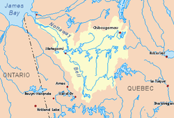
Théodat River
The Théodat River is a tributary of Evans Lake, in Regional County Municipality (MRC) of Eeyou Istchee Baie-James (municipality), in the administrative region from Nord-du-Québec, Canadian province of Quebec, in Canada.
| Théodat | |
|---|---|
 Watershed of Nottaway River | |
| Location | |
| Country | Canada |
| Province | Quebec |
| Region | Eeyou Istchee Baie-James (municipality) |
| Physical characteristics | |
| Source | Forested lake |
| • location | Eeyou Istchee Baie-James (municipality), Nord-du-Québec, Quebec |
| • coordinates | 50°50′02″N 76°34′50″W |
| • elevation | 317 m (1,040 ft) |
| Mouth | Evans Lake |
• location | Eeyou Istchee Baie-James (municipality), Nord-du-Québec, Quebec |
• coordinates | 50°59′19″N 76°34′50″W |
• elevation | 241 m (791 ft) |
| Length | 117.4 km (72.9 mi)[1] |
The hydrographic slope of the Théodat River is served by the northern route from Matagami passing 64 kilometres (40 mi) south-west of the mouth of the river. The surface of the river is usually frozen from early November to mid-May, however, safe ice circulation is generally from mid-November to mid-April.
Geography
The main hydrographic slopes near the Théodat River are:
- North side: Poles River, La Marte River, Nemiscau River, Le Gardeur Lake;
- East side: Broadback River, Assinica River;
- South side: Salamandre River, Broadback River, Nipukatasi River;
- West side: Evans Lake, Broadback River, Chabinoche River.
The Theodat River originates at the mouth of a little unidentified lake (length: 0.6 kilometres (0.37 mi) altitude: 317 metres (1,040 ft)). This source is located at:
- 64.4 kilometres (40.0 mi) Northeast of the mouth of the Théodat River;
- 84.6 kilometres (52.6 mi) Northeast of the mouth of Evans Lake;
- 132.6 kilometres (82.4 mi) Northeast of Soscumica Lake;
- 228 kilometres (142 mi) East of the mouth of the Broadback River);
- 182 kilometres (113 mi) Northeast of downtown Matagami.
From its source, the Théodat River flows on 117.4 kilometres (72.9 mi) according to the following segments:
Upper part of Theodat River (segment of 50.1 kilometres (31.1 mi) crossing the Assinica Wildlife Sanctuary)
- 7.4 kilometres (4.6 mi) southwesterly to the East shore of Hobier Lake;
- 7.9 kilometres (4.9 mi) Westward across Hobier Lake (length: 8.9 kilometres (5.5 mi); altitude: 312 metres (1,024 ft)) to its mouth;
- 2.6 kilometres (1.6 mi) Northeast, to a creek (coming from the East);
- 10.1 kilometres (6.3 mi) West, to the outlet (coming from the South) of an unidentified lake;
- 5.5 kilometres (3.4 mi) Westerly, to the discharge (coming from the North) of an unidentified lake;
- 8.2 kilometres (5.1 mi) Northwesterly to the dump (coming from the East) of an unidentified lake;
- 3.7 kilometres (2.3 mi) to the West, to the East bank of an unidentified lake;
- 4.7 kilometres (2.9 mi) to the North, in particular by crossing on an unidentified lake 2.2 kilometres (1.4 mi) (altitude: 283 metres (928 ft)) at the beginning of the segment, up to a small bay on the South shore of the Eastern part of Théodat Lake;
Lower part of Théodat River (segment of 67.3 kilometres (41.8 mi))
- 18.6 kilometres (11.6 mi) Westerly across the Théodat Lake (length: 20.1 kilometres (12.5 mi); altitude: 283 metres (928 ft)), up to at the dam at its mouth;
- 11.6 kilometres (7.2 mi) West through marsh areas, forming a curve to the North and a Southwesterly hook at the end of the segment, to the East shore of a unidentified lake;
- 7.1 kilometres (4.4 mi) Westward, crossing at the beginning of the segment on an unidentified lake (altitude: 261 metres (856 ft)) up to at the end of a bay on the South shore of Le Gardeur Lake;
- 9.2 kilometres (5.7 mi) Northwesterly across Le Gardeur Lake (length: 16.0 kilometres (9.9 mi); altitude: 254 metres (833 ft)), up to its mouth;
- 4.8 kilometres (3.0 mi) North crossing over a small unidentified lake to its mouth.[2]
The Theodat River flows into the Northeast bay of Evans Lake, facing an island with a length of 1.1 kilometres (0.68 mi). Evans Lake is crossed to the North by the Broadback River.
The mouth of Théodat River is located at:
- 20.2 kilometres (12.6 mi) East of the mouth of Evans Lake (confluence with the Broadback River);
- 96.9 kilometres (60.2 mi) Northeast of Soscumica Lake;
- 162.5 kilometres (101.0 mi) East of the mouth of the Broadback River;
- 155.6 kilometres (96.7 mi) North of downtown Matagami.
Toponymy
The toponym "Théodat River" was formalized on December 5, 1968, at the Commission de toponymie du Québec, i.e. at the creation of this commission[3]
References
- "Atlas of Canada". atlas.nrcan.gc.ca. Retrieved 2017-11-26.
- Distances from the Atlas of Canada (published on the Internet) from the Department of Natural Resources Canada.
- "Commission de toponymie du Québec - Place name bank - Toponym: "Théodat River"". toponymie.gouv.qc.ca. Retrieved 2017-11-25.
See also
- James Bay
- Rupert Bay
- Broadback River, a watercourse
- Evans Lake, a body of water
- Théodat Lake, a body of water
- Assinica Wildlife Sanctuary, a protected area
- List of rivers of Quebec